Linqiong elevation
Linqiong (Sichuan), China elevation is 511 meters and Linqiong elevation in feet is 1677 ft above sea level [src 1]. Linqiong is a populated place(s) (feature code) with elevation that is 47 meters (154 ft) smaller than average city elevation in China.
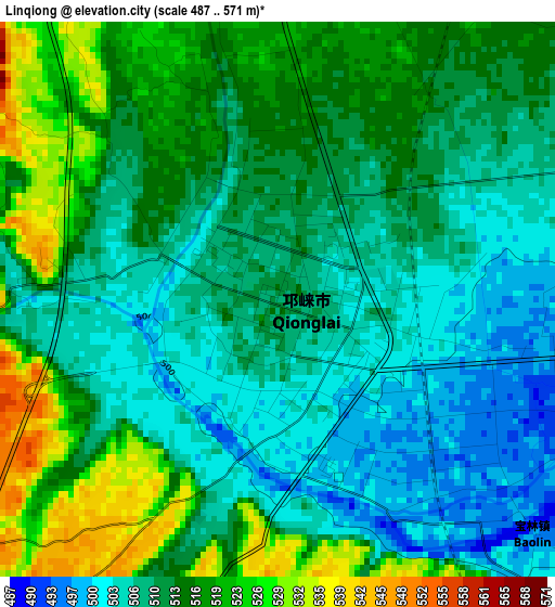
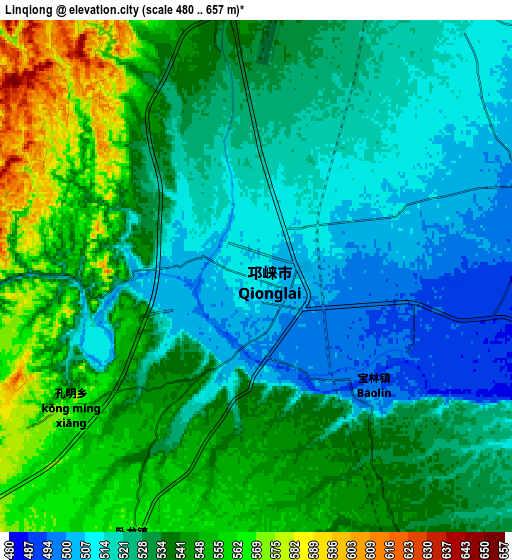
Below is the Elevation map of Linqiong, which displays elevation range with different colors. Scale of the first map is from 487 to 571 m (1598 to 1873 ft) with average elevation of 512 meters (=1680 ft) [note 1]
These maps also provides idea of topography and contour of this city, they are displayed at different zoom levels. More info about maps, scale and edge coordinates you can find below images.
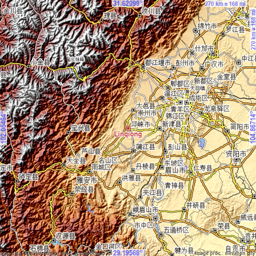
| \ | Map #1 | Map #2 | Topo.Map |
| Scale [m] | 487..571 m | 480..657 m | × |
| Scale [ft] | 1598..1873 ft | 1575..2156 ft | × |
| Average | 512 m = 1680 ft | 532.6 m = 1747 ft | × |
| Width | 8.43 km = 5.2 mi | 16.86 km = 10.5 mi | 269.7 km = 167.6 mi |
| Height | 8.43 km = 5.2 mi | 16.86 km = 10.5 mi | 269.7 km = 167.6 mi |
| ↑Max Latitude | 30.45376° | 30.491635° | 31.62099° |
| Latitude at center | 30.41587° | 30.41587° | 30.41587° |
| ↓Min Latitude | 30.377965° | 30.340046° | 29.19568° |
| ← Min Longitude | 103.416945° | 103.372999° | 102.05464° |
| Longitude center | 103.46089° | 103.46089° | 103.46089° |
| →Max Longitude | 103.504835° | 103.548781° | 104.86714° |
Nearby cities:
Cities around Linqiong sort by population:
• Chengdu elevation 499 m
64.4 km,  64°
64°
• Tianpeng 611 m
78.2 km,  35°
35°
• Xindu 495 m
80.5 km, 55°
• Wenlin 426 m
80.1 km,  125°
125°
• Longquan 523 m
79.1 km,  78°
78°
• Yancheng 415 m
75.4 km,  172°
172°
• Yucheng 591 m
65.3 km,  222°
222°
• Muping 1016 m
62.4 km,  265°
265°
• Pitong 564 m
59.6 km, 42°
• Liucheng 542 m
48 km,  48°
48°
• Dongsheng 509 m
47.5 km,  68°
68°
• Wujin 464 m
33.8 km,  90°
90°
Multilingual:
 En español:
Linqiong elevación 511 m.
 En France:
Linqiong élévation 511 m.
 Auf Deutsch:
Linqiong höhe über dem Meeresspiegel ist 511 m.

Sources and notes:
- [note 1] Map square and city borders are not equal. Map elevation data is calculated only from area inside that square.
- [src 1] Elevation data from geonames database provided with same terms of usage.
- [src 2] The elevation map of Linqiong is generated using elevation data from NASA's 3 arcsec (90m) resolution SRTM data.
- [src 3] Base (background) map © OpenStreetMap contributors tiles are generated by Geofabrik and OpenTopoMap.
Copyright & License:
This Linqiong Elevation Map is licensed under CC BY-SA. You may reuse any part from this page, if you give a proper credit by linking to this URL:
 More info on terms of use page.