Wenlin elevation
Wenlin (Sichuan), China elevation is 426 meters and Wenlin elevation in feet is 1398 ft above sea level [src 1]. Wenlin is a seat of a third-order administrative division (feature code) with elevation that is 132 meters (433 ft) smaller than average city elevation in China.
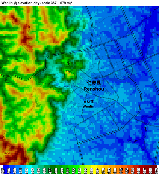
Below is the Elevation map of Wenlin, which displays elevation range with different colors. Scale of the first map is from 387 to 679 m (1270 to 2228 ft) with average elevation of 465.3 meters (=1527 ft) [note 1]
These maps also provides idea of topography and contour of this city, they are displayed at different zoom levels. More info about maps, scale and edge coordinates you can find below images.
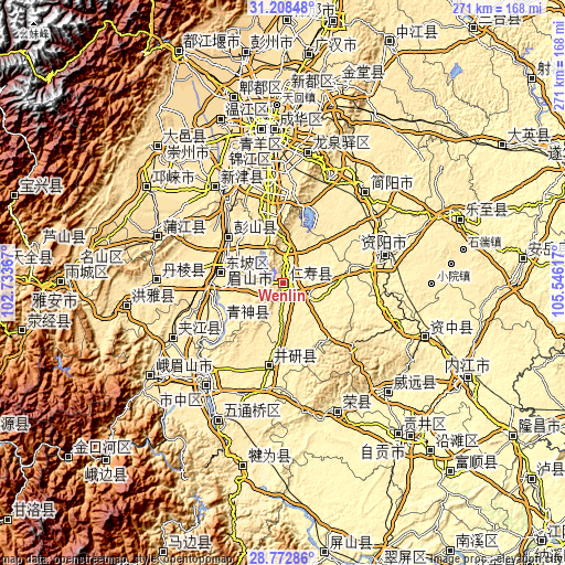
| \ | Map #1 | Topo.Map |
| Scale [m] | 387..679 m | × |
| Scale [ft] | 1270..2228 ft | × |
| Average | 465.3 m = 1527 ft | × |
| Width | 8.46 km = 5.3 mi | 270.8 km = 168.3 mi |
| Height | 8.46 km = 5.3 mi | 270.8 km = 168.3 mi |
| ↑Max Latitude | 30.036191° | 31.20848° |
| Latitude at center | 29.99814° | 29.99814° |
| ↓Min Latitude | 29.960074° | 28.77286° |
| ← Min Longitude | 104.095975° | 102.73367° |
| Longitude center | 104.13992° | 104.13992° |
| →Max Longitude | 104.183865° | 105.54617° |
Nearby cities:
Cities around Wenlin sort by population:
• Leshan elevation 375 m
60.5 km,  216°
216°
• Yanjiang 365 m
50.8 km,  74°
74°
• Luocheng 471 m
69 km,  188°
188°
• Chonglong 361 m
72.8 km,  109°
109°
• Yanling 318 m
72.3 km,  135°
135°
• Dongsheng 509 m
67.4 km,  341°
341°
• Xuyang 363 m
65.7 km,  155°
155°
• Longquan 523 m
63.8 km,  11°
11°
• Yancheng 415 m
62.1 km,  242°
242°
• Jiancheng 409 m
58.8 km,  41°
41°
• Wujin 464 m
55.7 km,  325°
325°
• Yancheng 389 m
39.3 km, 190°
Multilingual:
 En español:
Wenlin elevación 426 m.
 En France:
Wenlin élévation 426 m.


Sources and notes:
- [note 1] Map square and city borders are not equal. Map elevation data is calculated only from area inside that square.
- [src 1] Elevation data from geonames database provided with same terms of usage.
- [src 2] The elevation map of Wenlin is generated using elevation data from NASA's 3 arcsec (90m) resolution SRTM data.
- [src 3] Base (background) map © OpenStreetMap contributors tiles are generated by Geofabrik and OpenTopoMap.
Copyright & License:
This Wenlin Elevation Map is licensed under CC BY-SA. You may reuse any part from this page, if you give a proper credit by linking to this URL:
 More info on terms of use page.