Yanjiang elevation
Yanjiang (Sichuan), China elevation is 365 meters and Yanjiang elevation in feet is 1198 ft above sea level [src 1]. Yanjiang is a seat of a third-order administrative division (feature code) with elevation that is 193 meters (633 ft) smaller than average city elevation in China.
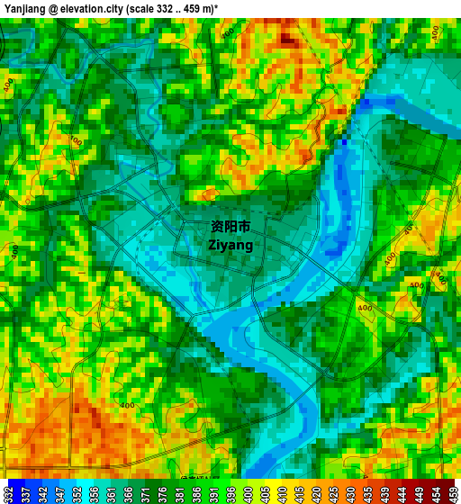
Below is the Elevation map of Yanjiang, which displays elevation range with different colors. Scale of the first map is from 332 to 459 m (1089 to 1506 ft) with average elevation of 383.1 meters (=1257 ft) [note 1]
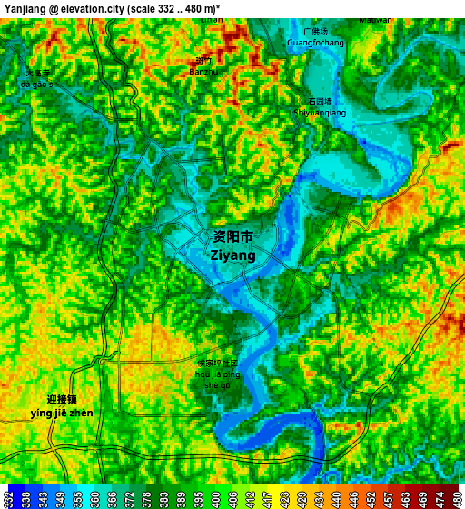
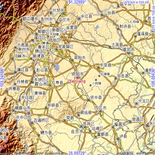
These maps also provides idea of topography and contour of this city, they are displayed at different zoom levels. More info about maps, scale and edge coordinates you can find below images.
| \ | Map #1 | Map #2 | Topo.Map |
| Scale [m] | 332..459 m | 332..480 m | × |
| Scale [ft] | 1089..1506 ft | 1089..1575 ft | × |
| Average | 383.1 m = 1257 ft | 394.2 m = 1293 ft | × |
| Width | 8.45 km = 5.3 mi | 16.91 km = 10.5 mi | 270.5 km = 168.1 mi |
| Height | 8.45 km = 5.3 mi | 16.91 km = 10.5 mi | 270.5 km = 168.1 mi |
| ↑Max Latitude | 30.159084° | 30.197073° | 31.32989° |
| Latitude at center | 30.12108° | 30.12108° | 30.12108° |
| ↓Min Latitude | 30.083061° | 30.045028° | 28.89729° |
| ← Min Longitude | 104.604165° | 104.560219° | 103.24186° |
| Longitude center | 104.64811° | 104.64811° | 104.64811° |
| →Max Longitude | 104.692055° | 104.736001° | 106.05436° |
Nearby cities:
Cities around Yanjiang sort by population:
• Chengdu elevation 499 m
82.4 km,  317°
317°
• Neijiang 349 m
71.9 km,  146°
146°
• Chonglong 361 m
42.7 km, 152°
• Anju 290 m
81.7 km,  71°
71°
• Penglai 316 m
77.3 km,  48°
48°
• Xuyang 363 m
76.8 km,  196°
196°
• Yancheng 389 m
76.6 km,  226°
226°
• Yanling 318 m
65.7 km,  178°
178°
• Longquan 523 m
61 km, 323°
• Wenlin 426 m
50.8 km,  254°
254°
• Tianchi 440 m
40.2 km,  63°
63°
• Jiancheng 409 m
31.5 km,  342°
342°
Multilingual:
 En español:
Yanjiang elevación 365 m.
 En France:
Yanjiang élévation 365 m.
 Auf Deutsch:
Yanjiang höhe über dem Meeresspiegel ist 365 m.

Sources and notes:
- [note 1] Map square and city borders are not equal. Map elevation data is calculated only from area inside that square.
- [src 1] Elevation data from geonames database provided with same terms of usage.
- [src 2] The elevation map of Yanjiang is generated using elevation data from NASA's 3 arcsec (90m) resolution SRTM data.
- [src 3] Base (background) map © OpenStreetMap contributors tiles are generated by Geofabrik and OpenTopoMap.
Copyright & License:
This Yanjiang Elevation Map is licensed under CC BY-SA. You may reuse any part from this page, if you give a proper credit by linking to this URL:
 More info on terms of use page.