Tianpeng elevation
Tianpeng (Sichuan), China elevation is 611 meters and Tianpeng elevation in feet is 2005 ft above sea level [src 1]. Tianpeng is a seat of a third-order administrative division (feature code) with elevation that is 53 meters (174 ft) bigger than average city elevation in China.
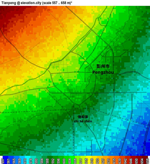
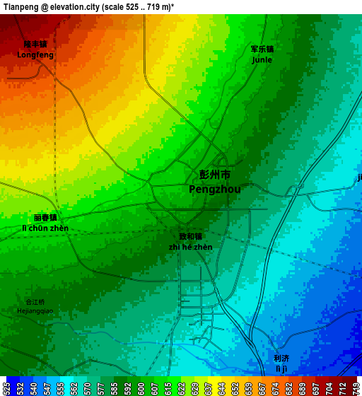
Below is the Elevation map of Tianpeng, which displays elevation range with different colors. Scale of the first map is from 557 to 658 m (1827 to 2159 ft) with average elevation of 600.4 meters (=1970 ft) [note 1]
These maps also provides idea of topography and contour of this city, they are displayed at different zoom levels. More info about maps, scale and edge coordinates you can find below images.
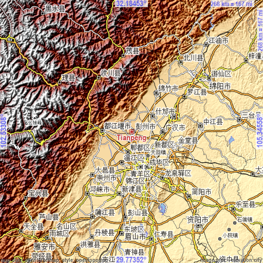
| \ | Map #1 | Map #2 | Topo.Map |
| Scale [m] | 557..658 m | 525..719 m | × |
| Scale [ft] | 1827..2159 ft | 1722..2359 ft | × |
| Average | 600.4 m = 1970 ft | 598.4 m = 1963 ft | × |
| Width | 8.38 km = 5.2 mi | 16.76 km = 10.4 mi | 268.1 km = 166.6 mi |
| Height | 8.38 km = 5.2 mi | 16.76 km = 10.4 mi | 268.1 km = 166.6 mi |
| ↑Max Latitude | 31.024306° | 31.061958° | 32.18453° |
| Latitude at center | 30.98664° | 30.98664° | 30.98664° |
| ↓Min Latitude | 30.948959° | 30.911263° | 29.77352° |
| ← Min Longitude | 103.895385° | 103.851439° | 102.53308° |
| Longitude center | 103.93933° | 103.93933° | 103.93933° |
| →Max Longitude | 103.983275° | 104.027221° | 105.34558° |
Nearby cities:
Cities around Tianpeng sort by population:
• Chengdu elevation 499 m
37.6 km,  161°
161°
• Deyang 501 m
45.1 km,  69°
69°
• Luojiang 509 m
64.4 km,  56°
56°
• Longquan 523 m
56.8 km,  146°
146°
• Zhaozhen 450 m
49.5 km,  107°
107°
• Jiannan 600 m
46.6 km,  31°
31°
• Dongsheng 509 m
45.9 km,  182°
182°
• Liucheng 542 m
33.3 km,  196°
196°
• Luocheng 482 m
32.6 km,  91°
91°
• Xindu 495 m
27.7 km,  131°
131°
• Fangting 529 m
26.7 km,  54°
54°
• Pitong 564 m
20.4 km, 195°
Multilingual:
 En español:
Tianpeng elevación 611 m.
 En France:
Tianpeng élévation 611 m.
 Auf Deutsch:
Tianpeng höhe über dem Meeresspiegel ist 611 m.

Sources and notes:
- [note 1] Map square and city borders are not equal. Map elevation data is calculated only from area inside that square.
- [src 1] Elevation data from geonames database provided with same terms of usage.
- [src 2] The elevation map of Tianpeng is generated using elevation data from NASA's 3 arcsec (90m) resolution SRTM data.
- [src 3] Base (background) map © OpenStreetMap contributors tiles are generated by Geofabrik and OpenTopoMap.
Copyright & License:
This Tianpeng Elevation Map is licensed under CC BY-SA. You may reuse any part from this page, if you give a proper credit by linking to this URL:
 More info on terms of use page.