Jinchuan elevation
Jinchuan (Sichuan), China elevation is 2199 meters and Jinchuan elevation in feet is 7215 ft above sea level [src 1]. Jinchuan is a seat of a third-order administrative division (feature code) with elevation that is 1641 meters (5384 ft) bigger than average city elevation in China.
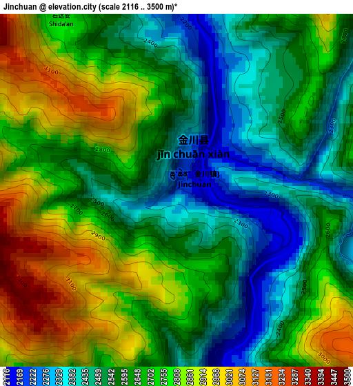
Below is the Elevation map of Jinchuan, which displays elevation range with different colors. Scale of the first map is from 2116 to 3500 m (6942 to 11483 ft) with average elevation of 2655.2 meters (=8711 ft) [note 1]
These maps also provides idea of topography and contour of this city, they are displayed at different zoom levels. More info about maps, scale and edge coordinates you can find below images.
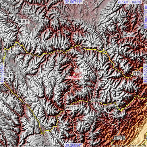
| \ | Map #1 | Topo.Map |
| Scale [m] | 2116..3500 m | × |
| Scale [ft] | 6942..11483 ft | × |
| Average | 2655.2 m = 8711 ft | × |
| Width | 8.33 km = 5.2 mi | 266.7 km = 165.7 mi |
| Height | 8.33 km = 5.2 mi | 266.7 km = 165.7 mi |
| ↑Max Latitude | 31.512982° | 32.66711° |
| Latitude at center | 31.47551° | 31.47551° |
| ↓Min Latitude | 31.438023° | 30.26854° |
| ← Min Longitude | 102.014895° | 100.65259° |
| Longitude center | 102.05884° | 102.05884° |
| →Max Longitude | 102.102785° | 103.46509° |
Nearby cities:
Cities around Jinchuan sort by population:
• Kangding elevation 2826 m
164.1 km,  183°
183°
• Aba 3277 m
162.5 km,  348°
348°
• Qiongxi 3493 m
153.4 km,  17°
17°
• Weizhou 1619 m
144.7 km,  89°
89°
• Muping 1016 m
142.3 km,  149°
149°
• Xindou 3185 m
131.2 km,  266°
266°
• Luhua 2346 m
109.7 km,  53°
53°
• Zagunao 1826 m
106.1 km, 91°
• Xianshui 3243 m
103.7 km,  238°
238°
• Zhanggu 2425 m
69.4 km,  193°
193°
• Meixing 2387 m
60.2 km, 151°
• Barkam 2621 m
49.7 km, 17°
Multilingual:
 En español:
Jinchuan elevación 2199 m.
 En France:
Jinchuan élévation 2199 m.
 Auf Deutsch:
Jinchuan höhe über dem Meeresspiegel ist 2199 m.

Sources and notes:
- [note 1] Map square and city borders are not equal. Map elevation data is calculated only from area inside that square.
- [src 1] Elevation data from geonames database provided with same terms of usage.
- [src 2] The elevation map of Jinchuan is generated using elevation data from NASA's 3 arcsec (90m) resolution SRTM data.
- [src 3] Base (background) map © OpenStreetMap contributors tiles are generated by Geofabrik and OpenTopoMap.
Copyright & License:
This Jinchuan Elevation Map is licensed under CC BY-SA. You may reuse any part from this page, if you give a proper credit by linking to this URL:
 More info on terms of use page.