Qiongxi elevation
Qiongxi (Sichuan), China elevation is 3493 meters and Qiongxi elevation in feet is 11460 ft above sea level [src 1]. Qiongxi is a seat of a third-order administrative division (feature code) with elevation that is 2935 meters (9629 ft) bigger than average city elevation in China.
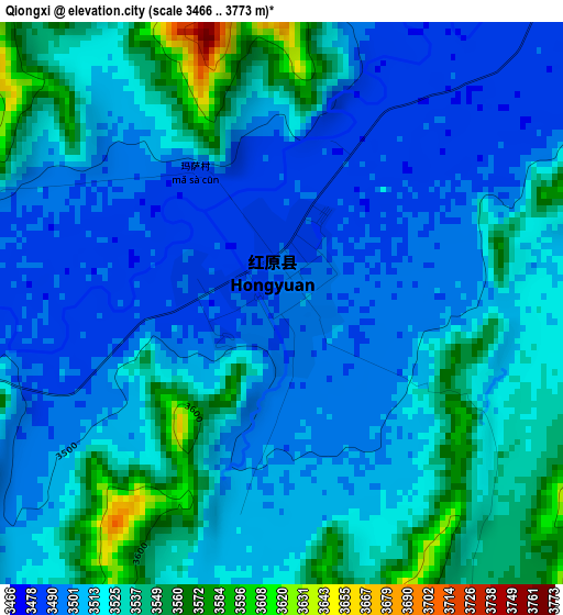
Below is the Elevation map of Qiongxi, which displays elevation range with different colors. Scale of the first map is from 3466 to 3773 m (11371 to 12379 ft) with average elevation of 3516.9 meters (=11538 ft) [note 1]
These maps also provides idea of topography and contour of this city, they are displayed at different zoom levels. More info about maps, scale and edge coordinates you can find below images.
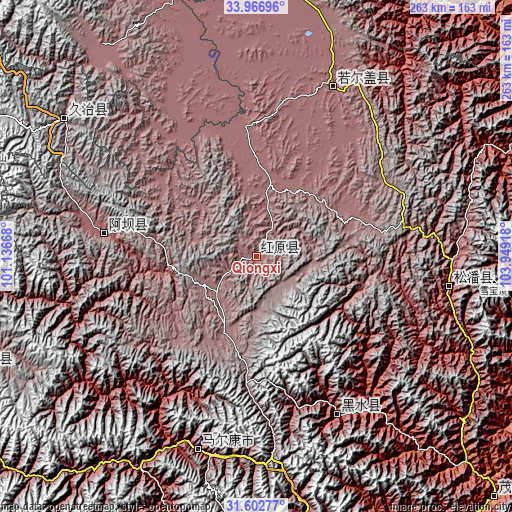
| \ | Map #1 | Topo.Map |
| Scale [m] | 3466..3773 m | × |
| Scale [ft] | 11371..12379 ft | × |
| Average | 3516.9 m = 11538 ft | × |
| Width | 8.22 km = 5.1 mi | 262.9 km = 163.4 mi |
| Height | 8.22 km = 5.1 mi | 262.9 km = 163.4 mi |
| ↑Max Latitude | 32.829654° | 33.96696° |
| Latitude at center | 32.79272° | 32.79272° |
| ↓Min Latitude | 32.75577° | 31.60277° |
| ← Min Longitude | 102.498985° | 101.13668° |
| Longitude center | 102.54293° | 102.54293° |
| →Max Longitude | 102.586875° | 103.94918° |
Nearby cities:
Cities around Qiongxi sort by population:
• Sailaitang elevation 3522 m
169.4 km,  275°
275°
• Yongle 1416 m
166 km,  71°
71°
• Zagunao 1826 m
161.2 km,  158°
158°
• Dianga 2499 m
154.4 km,  23°
23°
• Jinchuan 2199 m
153.4 km,  197°
197°
• Nyinma 3480 m
141.3 km,  341°
341°
• Zhiqing Songduo 3778 m
125.5 km,  304°
304°
• Barkam 2621 m
103.7 km, 196°
• Jin’an 2851 m
100.1 km,  99°
99°
• Dazhasi 3446 m
95.7 km, 24°
• Luhua 2346 m
90.8 km,  152°
152°
• Aba 3277 m
79.2 km, 279°
Multilingual:
 En español:
Qiongxi elevación 3493 m.
 En France:
Qiongxi élévation 3493 m.
 Auf Deutsch:
Qiongxi höhe über dem Meeresspiegel ist 3493 m.

Sources and notes:
- [note 1] Map square and city borders are not equal. Map elevation data is calculated only from area inside that square.
- [src 1] Elevation data from geonames database provided with same terms of usage.
- [src 2] The elevation map of Qiongxi is generated using elevation data from NASA's 3 arcsec (90m) resolution SRTM data.
- [src 3] Base (background) map © OpenStreetMap contributors tiles are generated by Geofabrik and OpenTopoMap.
Copyright & License:
This Qiongxi Elevation Map is licensed under CC BY-SA. You may reuse any part from this page, if you give a proper credit by linking to this URL:
 More info on terms of use page.