Sailaitang elevation
Sailaitang (Qinghai), China elevation is 3522 meters and Sailaitang elevation in feet is 11555 ft above sea level [src 1]. Sailaitang is a seat of a third-order administrative division (feature code) with elevation that is 2964 meters (9724 ft) bigger than average city elevation in China.
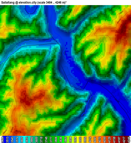
Below is the Elevation map of Sailaitang, which displays elevation range with different colors. Scale of the first map is from 3484 to 4246 m (11430 to 13930 ft) with average elevation of 3769.5 meters (=12367 ft) [note 1]
These maps also provides idea of topography and contour of this city, they are displayed at different zoom levels. More info about maps, scale and edge coordinates you can find below images.
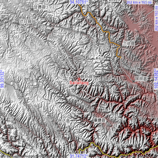
| \ | Map #1 | Topo.Map |
| Scale [m] | 3484..4246 m | × |
| Scale [ft] | 11430..13930 ft | × |
| Average | 3769.5 m = 12367 ft | × |
| Width | 8.2 km = 5.1 mi | 262.5 km = 163.1 mi |
| Height | 8.2 km = 5.1 mi | 262.5 km = 163.1 mi |
| ↑Max Latitude | 32.972065° | 34.10751° |
| Latitude at center | 32.93519° | 32.93519° |
| ↓Min Latitude | 32.8983° | 31.74712° |
| ← Min Longitude | 100.693625° | 99.33132° |
| Longitude center | 100.73757° | 100.73757° |
| →Max Longitude | 100.781515° | 102.14382° |
Nearby cities:
Cities around Sailaitang sort by population:
• Jinchuan elevation 2199 m
204.4 km,  142°
142°
• Barkam 2621 m
180.6 km,  129°
129°
• Dawu 3721 m
176.6 km,  344°
344°
• Nyinma 3480 m
171.3 km,  46°
46°
• Xindou 3185 m
171.2 km,  181°
181°
• Qiongxi 3493 m
169.4 km,  95°
95°
• Ganzi 3392 m
161.3 km,  205°
205°
• Kequ 4020 m
138.7 km,  325°
325°
• Jimai 3981 m
135.9 km,  311°
311°
• Aba 3277 m
90.5 km,  92°
92°
• Zhiqing Songduo 3778 m
85.2 km, 49°
• Seke 3884 m
83 km, 207°
Multilingual:
 En español:
Sailaitang elevación 3522 m.
 En France:
Sailaitang élévation 3522 m.
 Auf Deutsch:
Sailaitang höhe über dem Meeresspiegel ist 3522 m.

Sources and notes:
- [note 1] Map square and city borders are not equal. Map elevation data is calculated only from area inside that square.
- [src 1] Elevation data from geonames database provided with same terms of usage.
- [src 2] The elevation map of Sailaitang is generated using elevation data from NASA's 3 arcsec (90m) resolution SRTM data.
- [src 3] Base (background) map © OpenStreetMap contributors tiles are generated by Geofabrik and OpenTopoMap.
Copyright & License:
This Sailaitang Elevation Map is licensed under CC BY-SA. You may reuse any part from this page, if you give a proper credit by linking to this URL:
 More info on terms of use page.