Seke elevation
Seke (Sichuan), China elevation is 3884 meters and Seke elevation in feet is 12743 ft above sea level [src 1]. Seke is a seat of a third-order administrative division (feature code) with elevation that is 3326 meters (10912 ft) bigger than average city elevation in China.
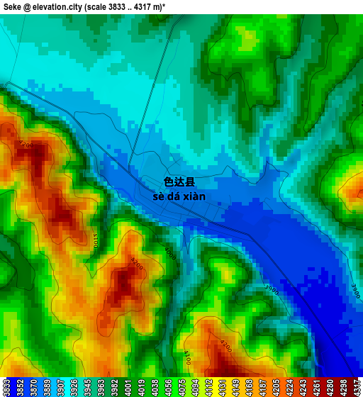
Below is the Elevation map of Seke, which displays elevation range with different colors. Scale of the first map is from 3833 to 4317 m (12575 to 14163 ft) with average elevation of 3997 meters (=13114 ft) [note 1]
These maps also provides idea of topography and contour of this city, they are displayed at different zoom levels. More info about maps, scale and edge coordinates you can find below images.
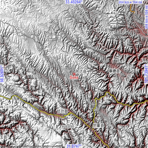
| \ | Map #1 | Topo.Map |
| Scale [m] | 3833..4317 m | × |
| Scale [ft] | 12575..14163 ft | × |
| Average | 3997 m = 13114 ft | × |
| Width | 8.26 km = 5.1 mi | 264.4 km = 164.3 mi |
| Height | 8.26 km = 5.1 mi | 264.4 km = 164.3 mi |
| ↑Max Latitude | 32.308609° | 33.45264° |
| Latitude at center | 32.27146° | 32.27146° |
| ↓Min Latitude | 32.234295° | 31.0747° |
| ← Min Longitude | 100.289215° | 98.92691° |
| Longitude center | 100.33316° | 100.33316° |
| →Max Longitude | 100.377105° | 101.73941° |
Nearby cities:
Cities around Seke sort by population:
• Kequ elevation 4020 m
193 km,  347°
347°
• Jinchuan 2199 m
185.4 km,  118°
118°
• Barkam 2621 m
182.6 km,  103°
103°
• Jimai 3981 m
176.5 km,  338°
338°
• Gengqing 4008 m
171.4 km,  252°
252°
• Zhiqing Songduo 3778 m
165.1 km,  38°
38°
• Xianshui 3243 m
160.9 km,  152°
152°
• Rulong 3050 m
147.9 km,  180°
180°
• Aba 3277 m
146.7 km,  61°
61°
• Xindou 3185 m
102.6 km,  161°
161°
• Sailaitang 3522 m
83 km,  27°
27°
• Ganzi 3392 m
78.4 km,  204°
204°
Multilingual:
 En español:
Seke elevación 3884 m.
 En France:
Seke élévation 3884 m.


Sources and notes:
- [note 1] Map square and city borders are not equal. Map elevation data is calculated only from area inside that square.
- [src 1] Elevation data from geonames database provided with same terms of usage.
- [src 2] The elevation map of Seke is generated using elevation data from NASA's 3 arcsec (90m) resolution SRTM data.
- [src 3] Base (background) map © OpenStreetMap contributors tiles are generated by Geofabrik and OpenTopoMap.
Copyright & License:
This Seke Elevation Map is licensed under CC BY-SA. You may reuse any part from this page, if you give a proper credit by linking to this URL:
 More info on terms of use page.