Rulong elevation
Rulong (Sichuan), China elevation is 3050 meters and Rulong elevation in feet is 10007 ft above sea level [src 1]. Rulong is a seat of a third-order administrative division (feature code) with elevation that is 2492 meters (8176 ft) bigger than average city elevation in China.
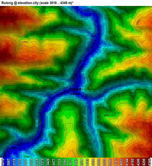
Below is the Elevation map of Rulong, which displays elevation range with different colors. Scale of the first map is from 3016 to 4349 m (9895 to 14268 ft) with average elevation of 3579.2 meters (=11743 ft) [note 1]
These maps also provides idea of topography and contour of this city, they are displayed at different zoom levels. More info about maps, scale and edge coordinates you can find below images.
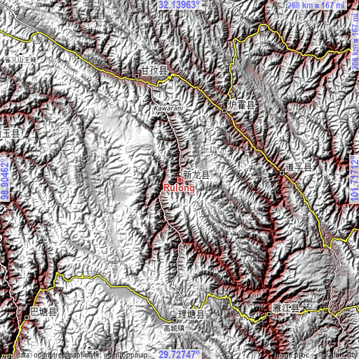
| \ | Map #1 | Topo.Map |
| Scale [m] | 3016..4349 m | × |
| Scale [ft] | 9895..14268 ft | × |
| Average | 3579.2 m = 11743 ft | × |
| Width | 8.38 km = 5.2 mi | 268.2 km = 166.7 mi |
| Height | 8.38 km = 5.2 mi | 268.2 km = 166.7 mi |
| ↑Max Latitude | 30.978844° | 32.13963° |
| Latitude at center | 30.94116° | 30.94116° |
| ↓Min Latitude | 30.903461° | 29.72747° |
| ← Min Longitude | 100.266925° | 98.90462° |
| Longitude center | 100.31087° | 100.31087° |
| →Max Longitude | 100.354815° | 101.71712° |
Nearby cities:
Cities around Rulong sort by population:
• Kangding elevation 2826 m
189.2 km,  123°
123°
• Jomda 3605 m
208.9 km,  287°
287°
• Meixing 2387 m
195.5 km,  88°
88°
• Molo 3619 m
194.6 km,  267°
267°
• Gengqing 4008 m
189.7 km,  300°
300°
• Jinchuan 2199 m
176.5 km,  70°
70°
• Zhanggu 2425 m
150.7 km, 93°
• Seke 3884 m
147.9 km,  0°
0°
• Gaocheng 3935 m
106 km,  182°
182°
• Ganzi 3392 m
82 km,  338°
338°
• Xianshui 3243 m
78 km, 85°
• Xindou 3185 m
61.5 km,  34°
34°
Multilingual:
 En español:
Rulong elevación 3050 m.
 En France:
Rulong élévation 3050 m.


Sources and notes:
- [note 1] Map square and city borders are not equal. Map elevation data is calculated only from area inside that square.
- [src 1] Elevation data from geonames database provided with same terms of usage.
- [src 2] The elevation map of Rulong is generated using elevation data from NASA's 3 arcsec (90m) resolution SRTM data.
- [src 3] Base (background) map © OpenStreetMap contributors tiles are generated by Geofabrik and OpenTopoMap.
Copyright & License:
This Rulong Elevation Map is licensed under CC BY-SA. You may reuse any part from this page, if you give a proper credit by linking to this URL:
 More info on terms of use page.