Gengqing elevation
Gengqing (Sichuan), China elevation is 4008 meters and Gengqing elevation in feet is 13150 ft above sea level [src 1]. Gengqing is a seat of a third-order administrative division (feature code) with elevation that is 3450 meters (11319 ft) bigger than average city elevation in China.
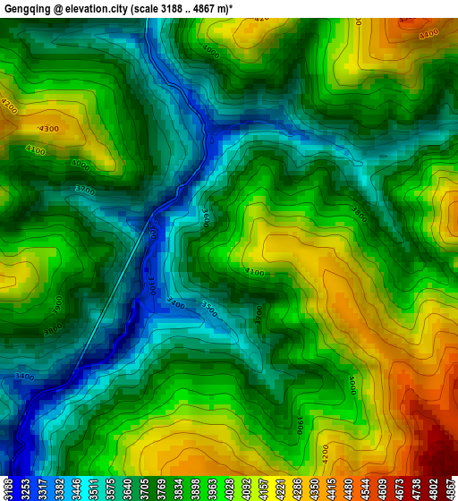
Below is the Elevation map of Gengqing, which displays elevation range with different colors. Scale of the first map is from 3188 to 4867 m (10459 to 15968 ft) with average elevation of 3858.1 meters (=12658 ft) [note 1]
These maps also provides idea of topography and contour of this city, they are displayed at different zoom levels. More info about maps, scale and edge coordinates you can find below images.
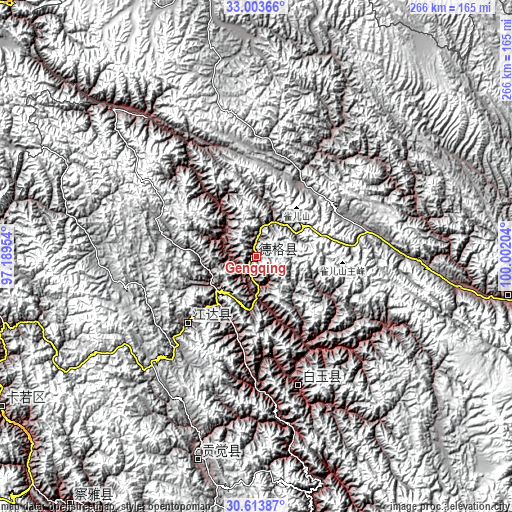
| \ | Map #1 | Topo.Map |
| Scale [m] | 3188..4867 m | × |
| Scale [ft] | 10459..15968 ft | × |
| Average | 3858.1 m = 12658 ft | × |
| Width | 8.3 km = 5.2 mi | 265.7 km = 165.1 mi |
| Height | 8.3 km = 5.2 mi | 265.7 km = 165.1 mi |
| ↑Max Latitude | 31.853825° | 33.00366° |
| Latitude at center | 31.81649° | 31.81649° |
| ↓Min Latitude | 31.77914° | 30.61387° |
| ← Min Longitude | 98.551845° | 97.18954° |
| Longitude center | 98.59579° | 98.59579° |
| →Max Longitude | 98.639735° | 100.00204° |
Nearby cities:
Cities around Gengqing sort by population:
• Qamdo elevation 3235 m
154.4 km,  240°
240°
• Xindou 3185 m
202.7 km,  103°
103°
• Racaka 5015 m
202.3 km,  256°
256°
• Samdo 3802 m
200.7 km,  250°
250°
• Rulong 3050 m
189.7 km,  120°
120°
• Seke 3884 m
171.4 km,  72°
72°
• Yanduo 3159 m
161.5 km,  217°
217°
• Qümong 4183 m
137.3 km,  340°
340°
• Ganzi 3392 m
133.9 km, 99°
• Moluo 4451 m
122 km,  202°
202°
• Molo 3619 m
110.7 km, 196°
• Jomda 3605 m
50.9 km,  225°
225°
Multilingual:
 En español:
Gengqing elevación 4008 m.
 En France:
Gengqing élévation 4008 m.
 Auf Deutsch:
Gengqing höhe über dem Meeresspiegel ist 4008 m.

Sources and notes:
- [note 1] Map square and city borders are not equal. Map elevation data is calculated only from area inside that square.
- [src 1] Elevation data from geonames database provided with same terms of usage.
- [src 2] The elevation map of Gengqing is generated using elevation data from NASA's 3 arcsec (90m) resolution SRTM data.
- [src 3] Base (background) map © OpenStreetMap contributors tiles are generated by Geofabrik and OpenTopoMap.
Copyright & License:
This Gengqing Elevation Map is licensed under CC BY-SA. You may reuse any part from this page, if you give a proper credit by linking to this URL:
 More info on terms of use page.