Qamdo elevation
Qamdo (Tibet), China elevation is 3235 meters and Qamdo elevation in feet is 10614 ft above sea level [src 1]. Qamdo is a seat of a second-order administrative division (feature code) with elevation that is 2677 meters (8783 ft) bigger than average city elevation in China.
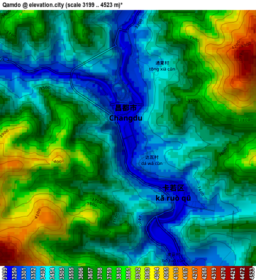
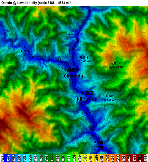
Below is the Elevation map of Qamdo, which displays elevation range with different colors. Scale of the first map is from 3199 to 4523 m (10495 to 14839 ft) with average elevation of 3606.2 meters (=11831 ft) [note 1]
These maps also provides idea of topography and contour of this city, they are displayed at different zoom levels. More info about maps, scale and edge coordinates you can find below images.
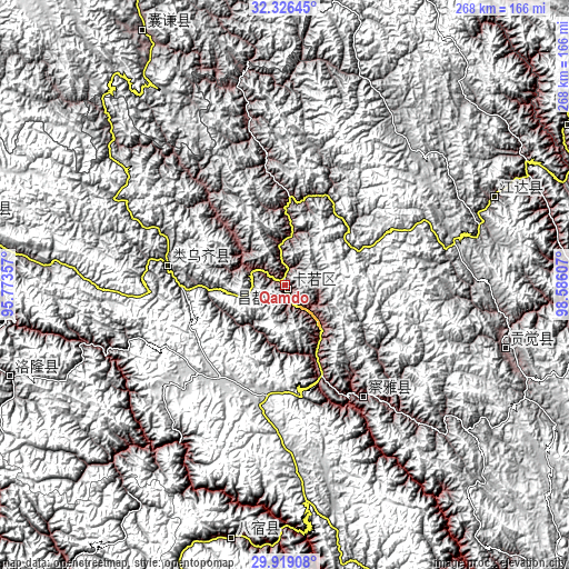
| \ | Map #1 | Map #2 | Topo.Map |
| Scale [m] | 3199..4523 m | 3188..4863 m | × |
| Scale [ft] | 10495..14839 ft | 10459..15955 ft | × |
| Average | 3606.2 m = 11831 ft | 3802.2 m = 12474 ft | × |
| Width | 8.37 km = 5.2 mi | 16.73 km = 10.4 mi | 267.7 km = 166.3 mi |
| Height | 8.37 km = 5.2 mi | 16.73 km = 10.4 mi | 267.7 km = 166.3 mi |
| ↑Max Latitude | 31.168009° | 31.205604° | 32.32645° |
| Latitude at center | 31.1304° | 31.1304° | 31.1304° |
| ↓Min Latitude | 31.092776° | 31.055136° | 29.91908° |
| ← Min Longitude | 97.135875° | 97.091929° | 95.77357° |
| Longitude center | 97.17982° | 97.17982° | 97.17982° |
| →Max Longitude | 97.223765° | 97.267711° | 98.58607° |
Nearby cities:
Cities around Qamdo sort by population:
• Gyamotang elevation 4955 m
171.8 km,  285°
285°
• Dingqing 3878 m
154.8 km,  281°
281°
• Gengqing 4008 m
154.4 km,  60°
60°
• Xangda 3655 m
136.7 km,  330°
330°
• Zito 3728 m
135.3 km,  251°
251°
• Baima 3258 m
121.9 km,  191°
191°
• Molo 3619 m
108.4 km,  106°
106°
• Jomda 3605 m
106.1 km,  67°
67°
• Moluo 4451 m
95 km, 112°
• Racaka 5015 m
69.8 km,  295°
295°
• Yanduo 3159 m
64.6 km,  144°
144°
• Samdo 3802 m
56 km, 279°
Multilingual:
 En español:
Qamdo elevación 3235 m.
 En France:
Qamdo élévation 3235 m.


Sources and notes:
- [note 1] Map square and city borders are not equal. Map elevation data is calculated only from area inside that square.
- [src 1] Elevation data from geonames database provided with same terms of usage.
- [src 2] The elevation map of Qamdo is generated using elevation data from NASA's 3 arcsec (90m) resolution SRTM data.
- [src 3] Base (background) map © OpenStreetMap contributors tiles are generated by Geofabrik and OpenTopoMap.
Copyright & License:
This Qamdo Elevation Map is licensed under CC BY-SA. You may reuse any part from this page, if you give a proper credit by linking to this URL:
 More info on terms of use page.