Gaocheng elevation
Gaocheng (Sichuan), China elevation is 3935 meters and Gaocheng elevation in feet is 12910 ft above sea level [src 1]. Gaocheng is a seat of a third-order administrative division (feature code) with elevation that is 3377 meters (11079 ft) bigger than average city elevation in China.
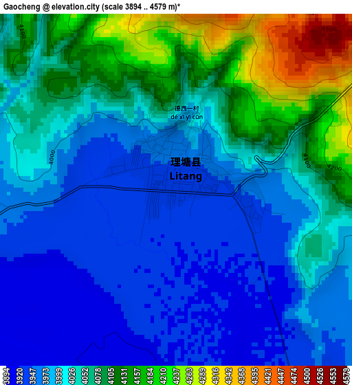
Below is the Elevation map of Gaocheng, which displays elevation range with different colors. Scale of the first map is from 3894 to 4579 m (12776 to 15023 ft) with average elevation of 4032.3 meters (=13229 ft) [note 1]
These maps also provides idea of topography and contour of this city, they are displayed at different zoom levels. More info about maps, scale and edge coordinates you can find below images.
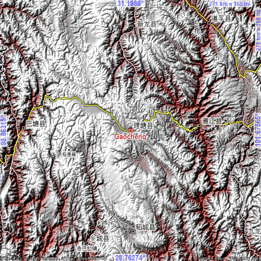
| \ | Map #1 | Topo.Map |
| Scale [m] | 3894..4579 m | × |
| Scale [ft] | 12776..15023 ft | × |
| Average | 4032.3 m = 13229 ft | × |
| Width | 8.46 km = 5.3 mi | 270.8 km = 168.3 mi |
| Height | 8.46 km = 5.3 mi | 270.8 km = 168.3 mi |
| ↑Max Latitude | 30.026195° | 31.1986° |
| Latitude at center | 29.98814° | 29.98814° |
| ↓Min Latitude | 29.95007° | 28.76274° |
| ← Min Longitude | 100.225455° | 98.86315° |
| Longitude center | 100.2694° | 100.2694° |
| →Max Longitude | 100.313345° | 101.67565° |
Nearby cities:
Cities around Gaocheng sort by population:
• Kangding elevation 2826 m
162.5 km,  89°
89°
• Shengping 3362 m
212.8 km,  218°
218°
• Luqiao 1414 m
189.1 km, 91°
• Ganzi 3392 m
184.2 km,  351°
351°
• Zhanggu 2425 m
183.5 km,  57°
57°
• Songmai 2399 m
170.7 km,  213°
213°
• Gartog 3867 m
165 km,  258°
258°
• Xia’er 3435 m
162.6 km,  132°
132°
• Xindou 3185 m
161.4 km,  14°
14°
• Xianshui 3243 m
138.6 km,  36°
36°
• Sangpi 2888 m
125.7 km,  201°
201°
• Rulong 3050 m
106 km,  2°
2°
Multilingual:
 En español:
Gaocheng elevación 3935 m.
 En France:
Gaocheng élévation 3935 m.
 Auf Deutsch:
Gaocheng höhe über dem Meeresspiegel ist 3935 m.

Sources and notes:
- [note 1] Map square and city borders are not equal. Map elevation data is calculated only from area inside that square.
- [src 1] Elevation data from geonames database provided with same terms of usage.
- [src 2] The elevation map of Gaocheng is generated using elevation data from NASA's 3 arcsec (90m) resolution SRTM data.
- [src 3] Base (background) map © OpenStreetMap contributors tiles are generated by Geofabrik and OpenTopoMap.
Copyright & License:
This Gaocheng Elevation Map is licensed under CC BY-SA. You may reuse any part from this page, if you give a proper credit by linking to this URL:
 More info on terms of use page.