Sangpi elevation
Sangpi (Sichuan), China elevation is 2888 meters and Sangpi elevation in feet is 9475 ft above sea level [src 1]. Sangpi is a seat of a third-order administrative division (feature code) with elevation that is 2330 meters (7644 ft) bigger than average city elevation in China.
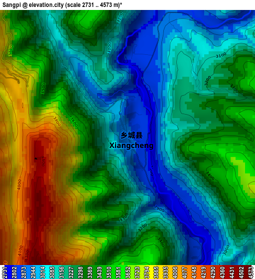
Below is the Elevation map of Sangpi, which displays elevation range with different colors. Scale of the first map is from 2731 to 4573 m (8960 to 15003 ft) with average elevation of 3368.2 meters (=11051 ft) [note 1]
These maps also provides idea of topography and contour of this city, they are displayed at different zoom levels. More info about maps, scale and edge coordinates you can find below images.
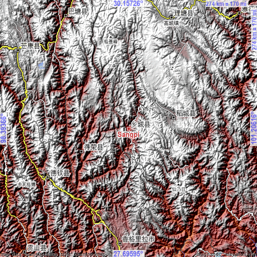
| \ | Map #1 | Topo.Map |
| Scale [m] | 2731..4573 m | × |
| Scale [ft] | 8960..15003 ft | × |
| Average | 3368.2 m = 11051 ft | × |
| Width | 8.55 km = 5.3 mi | 273.7 km = 170.1 mi |
| Height | 8.55 km = 5.3 mi | 273.7 km = 170.1 mi |
| ↑Max Latitude | 28.972363° | 30.15726° |
| Latitude at center | 28.93391° | 28.93391° |
| ↓Min Latitude | 28.895443° | 27.69595° |
| ← Min Longitude | 99.755965° | 98.39366° |
| Longitude center | 99.79991° | 99.79991° |
| →Max Longitude | 99.843855° | 101.20616° |
Nearby cities:
Cities around Sangpi sort by population:
• Shangri-La elevation 3283 m
123.6 km,  184°
184°
• Daxing 2430 m
213 km,  150°
150°
• Wangda 3806 m
207.3 km,  293°
293°
• Baohe 2591 m
198.8 km,  193°
193°
• Qiaowa 2304 m
182.5 km,  127°
127°
• Cikai 2471 m
168.2 km,  219°
219°
• Xia’er 3435 m
167 km,  87°
87°
• Gartog 3867 m
143.6 km,  305°
305°
• Gaocheng 3935 m
125.7 km,  21°
21°
• Jiantang 3338 m
123.6 km, 181°
• Shengping 3362 m
100 km,  240°
240°
• Songmai 2399 m
55.7 km, 244°
Multilingual:
 En español:
Sangpi elevación 2888 m.
 En France:
Sangpi élévation 2888 m.


Sources and notes:
- [note 1] Map square and city borders are not equal. Map elevation data is calculated only from area inside that square.
- [src 1] Elevation data from geonames database provided with same terms of usage.
- [src 2] The elevation map of Sangpi is generated using elevation data from NASA's 3 arcsec (90m) resolution SRTM data.
- [src 3] Base (background) map © OpenStreetMap contributors tiles are generated by Geofabrik and OpenTopoMap.
Copyright & License:
This Sangpi Elevation Map is licensed under CC BY-SA. You may reuse any part from this page, if you give a proper credit by linking to this URL:
 More info on terms of use page.