Daxing elevation
Daxing (Yunnan), China elevation is 2430 meters and Daxing elevation in feet is 7972 ft above sea level [src 1]. Daxing is a seat of a third-order administrative division (feature code) with elevation that is 1872 meters (6142 ft) bigger than average city elevation in China.
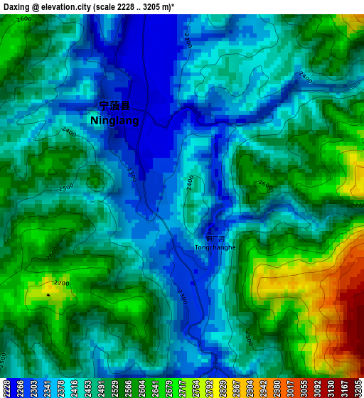
Below is the Elevation map of Daxing, which displays elevation range with different colors. Scale of the first map is from 2228 to 3205 m (7310 to 10515 ft) with average elevation of 2482.5 meters (=8145 ft) [note 1]
These maps also provides idea of topography and contour of this city, they are displayed at different zoom levels. More info about maps, scale and edge coordinates you can find below images.
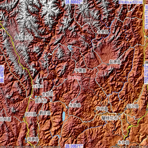
| \ | Map #1 | Topo.Map |
| Scale [m] | 2228..3205 m | × |
| Scale [ft] | 7310..10515 ft | × |
| Average | 2482.5 m = 8145 ft | × |
| Width | 8.69 km = 5.4 mi | 278 km = 172.7 mi |
| Height | 8.69 km = 5.4 mi | 278 km = 172.7 mi |
| ↑Max Latitude | 27.302746° | 28.50662° |
| Latitude at center | 27.26369° | 27.26369° |
| ↓Min Latitude | 27.22462° | 26.00671° |
| ← Min Longitude | 100.819925° | 99.45762° |
| Longitude center | 100.86387° | 100.86387° |
| →Max Longitude | 100.907815° | 102.27012° |
Nearby cities:
Cities around Daxing sort by population:
• Lijiang elevation 2397 m
77.4 km,  235°
235°
• Dadukou 1110 m
115.3 km,  133°
133°
• Renhe 1110 m
121.5 km, 134°
• Tongzilin 1012 m
116.2 km,  122°
122°
• Panzhihua 1101 m
113 km, 131°
• Yunhe 2195 m
105.4 km,  218°
218°
• Xiqu 1094 m
103.2 km,  135°
135°
• Qiaowa 2304 m
84.6 km,  28°
28°
• Zhongxin 1226 m
82.5 km,  150°
150°
• Huangshan 2378 m
80.3 km,  232°
232°
• Yongbei 2537 m
69.1 km,  186°
186°
• Yanjing 2550 m
66.3 km,  74°
74°
Multilingual:
 En español:
Daxing elevación 2430 m.
 En France:
Daxing élévation 2430 m.


Sources and notes:
- [note 1] Map square and city borders are not equal. Map elevation data is calculated only from area inside that square.
- [src 1] Elevation data from geonames database provided with same terms of usage.
- [src 2] The elevation map of Daxing is generated using elevation data from NASA's 3 arcsec (90m) resolution SRTM data.
- [src 3] Base (background) map © OpenStreetMap contributors tiles are generated by Geofabrik and OpenTopoMap.
Copyright & License:
This Daxing Elevation Map is licensed under CC BY-SA. You may reuse any part from this page, if you give a proper credit by linking to this URL:
 More info on terms of use page.