Dadukou elevation
Dadukou (Sichuan), China elevation is 1110 meters and Dadukou elevation in feet is 3642 ft above sea level [src 1]. Dadukou is a seat of a third-order administrative division (feature code) with elevation that is 552 meters (1811 ft) bigger than average city elevation in China.
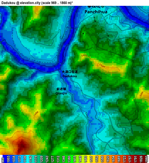
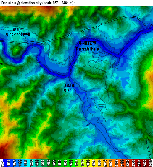
Below is the Elevation map of Dadukou, which displays elevation range with different colors. Scale of the first map is from 969 to 1860 m (3179 to 6102 ft) with average elevation of 1232.3 meters (=4043 ft) [note 1]
These maps also provides idea of topography and contour of this city, they are displayed at different zoom levels. More info about maps, scale and edge coordinates you can find below images.
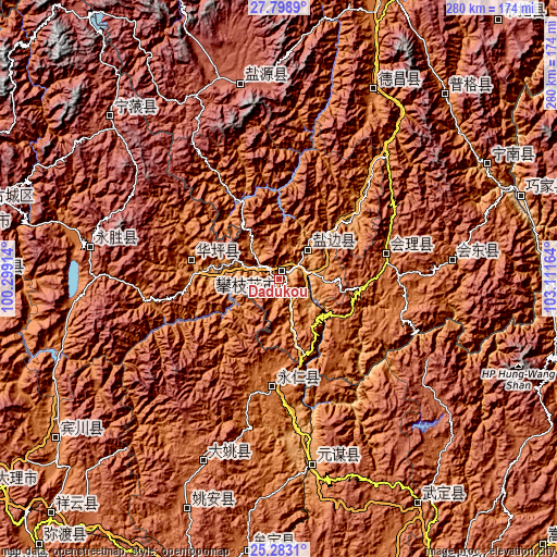
| \ | Map #1 | Map #2 | Topo.Map |
| Scale [m] | 969..1860 m | 957..2481 m | × |
| Scale [ft] | 3179..6102 ft | 3140..8140 ft | × |
| Average | 1232.3 m = 4043 ft | 1375.2 m = 4512 ft | × |
| Width | 8.74 km = 5.4 mi | 17.48 km = 10.9 mi | 279.7 km = 173.8 mi |
| Height | 8.74 km = 5.4 mi | 17.48 km = 10.9 mi | 279.7 km = 173.8 mi |
| ↑Max Latitude | 26.587205° | 26.626497° | 27.7989° |
| Latitude at center | 26.5479° | 26.5479° | 26.5479° |
| ↓Min Latitude | 26.508582° | 26.46925° | 25.2831° |
| ← Min Longitude | 101.661445° | 101.617499° | 100.29914° |
| Longitude center | 101.70539° | 101.70539° | 101.70539° |
| →Max Longitude | 101.749335° | 101.793281° | 103.11164° |
Nearby cities:
Cities around Dadukou sort by population:
• Yanjing elevation 2550 m
99.7 km,  348°
348°
• Yuanmou 1085 m
95 km,  170°
170°
• Yongbei 2537 m
92.6 km,  276°
276°
• Huidong 1676 m
87.1 km,  83°
83°
• Yongding 1517 m
56.4 km,  181°
181°
• Huili Chengguanzhen 1798 m
55 km, 76°
• Panlian 1099 m
55 km,  46°
46°
• Zhongxin 1226 m
43.8 km, 280°
• Tongzilin 1012 m
22.3 km,  40°
40°
• Xiqu 1094 m
12.4 km,  301°
301°
• Renhe 1110 m
6.3 km,  148°
148°
• Panzhihua 1101 m
4.2 km,  10°
10°
Multilingual:
 En español:
Dadukou elevación 1110 m.
 En France:
Dadukou élévation 1110 m.
 Auf Deutsch:
Dadukou höhe über dem Meeresspiegel ist 1110 m.

Sources and notes:
- [note 1] Map square and city borders are not equal. Map elevation data is calculated only from area inside that square.
- [src 1] Elevation data from geonames database provided with same terms of usage.
- [src 2] The elevation map of Dadukou is generated using elevation data from NASA's 3 arcsec (90m) resolution SRTM data.
- [src 3] Base (background) map © OpenStreetMap contributors tiles are generated by Geofabrik and OpenTopoMap.
Copyright & License:
This Dadukou Elevation Map is licensed under CC BY-SA. You may reuse any part from this page, if you give a proper credit by linking to this URL:
 More info on terms of use page.