Wangda elevation
Wangda (Tibet), China elevation is 3806 meters and Wangda elevation in feet is 12487 ft above sea level [src 1]. Wangda is a seat of a third-order administrative division (feature code) with elevation that is 3248 meters (10656 ft) bigger than average city elevation in China.
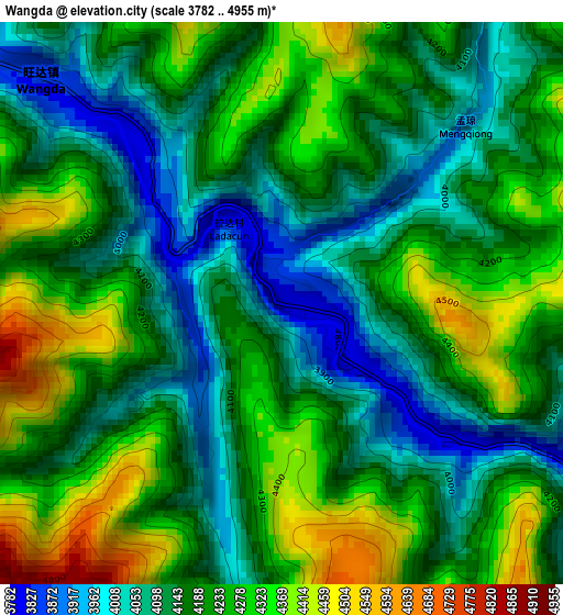
Below is the Elevation map of Wangda, which displays elevation range with different colors. Scale of the first map is from 3782 to 4955 m (12408 to 16257 ft) with average elevation of 4191.1 meters (=13750 ft) [note 1]
These maps also provides idea of topography and contour of this city, they are displayed at different zoom levels. More info about maps, scale and edge coordinates you can find below images.
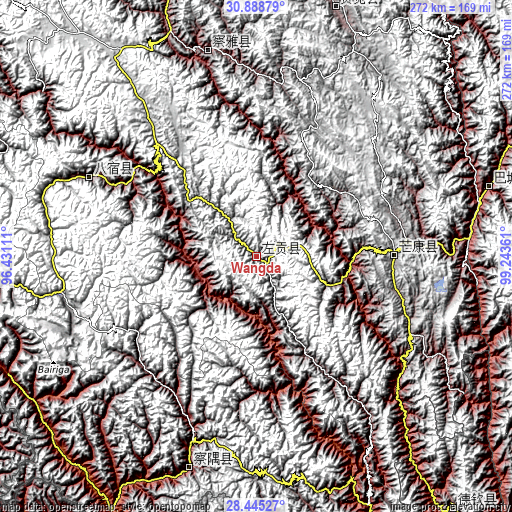
| \ | Map #1 | Topo.Map |
| Scale [m] | 3782..4955 m | × |
| Scale [ft] | 12408..16257 ft | × |
| Average | 4191.1 m = 13750 ft | × |
| Width | 8.49 km = 5.3 mi | 271.7 km = 168.8 mi |
| Height | 8.49 km = 5.3 mi | 271.7 km = 168.8 mi |
| ↑Max Latitude | 29.712625° | 30.88879° |
| Latitude at center | 29.67445° | 29.67445° |
| ↓Min Latitude | 29.636261° | 28.44527° |
| ← Min Longitude | 97.793415° | 96.43111° |
| Longitude center | 97.83736° | 97.83736° |
| →Max Longitude | 97.881305° | 99.24361° |
Nearby cities:
Cities around Wangda sort by population:
• Qamdo elevation 3235 m
173.7 km,  338°
338°
• Jomda 3605 m
205.7 km,  10°
10°
• Zhamog 2736 m
201.7 km,  276°
276°
• Songmai 2399 m
176.5 km,  127°
127°
• Shengping 3362 m
168.4 km,  141°
141°
• Molo 3619 m
138.3 km,  17°
17°
• Moluo 4451 m
128.1 km, 11°
• Zhowagoin 2654 m
119 km,  198°
198°
• Gyigang 3284 m
116.3 km, 195°
• Yanduo 3159 m
112.2 km,  346°
346°
• Baima 3258 m
98.3 km,  295°
295°
• Gartog 3867 m
73.2 km,  89°
89°
Multilingual:
 En español:
Wangda elevación 3806 m.
 En France:
Wangda élévation 3806 m.


Sources and notes:
- [note 1] Map square and city borders are not equal. Map elevation data is calculated only from area inside that square.
- [src 1] Elevation data from geonames database provided with same terms of usage.
- [src 2] The elevation map of Wangda is generated using elevation data from NASA's 3 arcsec (90m) resolution SRTM data.
- [src 3] Base (background) map © OpenStreetMap contributors tiles are generated by Geofabrik and OpenTopoMap.
Copyright & License:
This Wangda Elevation Map is licensed under CC BY-SA. You may reuse any part from this page, if you give a proper credit by linking to this URL:
 More info on terms of use page.