Zhowagoin elevation
Zhowagoin (Tibet), China elevation is 2654 meters and Zhowagoin elevation in feet is 8707 ft above sea level [src 1]. Zhowagoin is a seat of a third-order administrative division (feature code) with elevation that is 2096 meters (6877 ft) bigger than average city elevation in China.
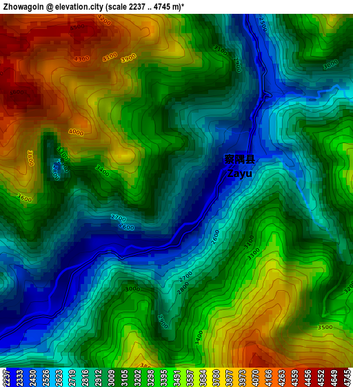
Below is the Elevation map of Zhowagoin, which displays elevation range with different colors. Scale of the first map is from 2237 to 4745 m (7339 to 15568 ft) with average elevation of 3178.5 meters (=10428 ft) [note 1]
These maps also provides idea of topography and contour of this city, they are displayed at different zoom levels. More info about maps, scale and edge coordinates you can find below images.
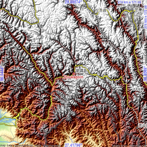
| \ | Map #1 | Topo.Map |
| Scale [m] | 2237..4745 m | × |
| Scale [ft] | 7339..15568 ft | × |
| Average | 3178.5 m = 10428 ft | × |
| Width | 8.58 km = 5.3 mi | 274.4 km = 170.5 mi |
| Height | 8.58 km = 5.3 mi | 274.4 km = 170.5 mi |
| ↑Max Latitude | 28.697654° | 29.88574° |
| Latitude at center | 28.6591° | 28.6591° |
| ↓Min Latitude | 28.620531° | 27.41794° |
| ← Min Longitude | 97.406705° | 96.0444° |
| Longitude center | 97.45065° | 97.45065° |
| →Max Longitude | 97.494595° | 98.8569° |
Nearby cities:
Cities around Zhowagoin sort by population:
• Shangri-La elevation 3283 m
239.7 km,  112°
112°
• Sangpi 2888 m
230.9 km,  82°
82°
• Yanduo 3159 m
222.5 km,  3°
3°
• Motuo 977 m
220.8 km,  289°
289°
• Zhamog 2736 m
212 km,  309°
309°
• Songmai 2399 m
179.2 km,  88°
88°
• Baima 3258 m
163.8 km,  341°
341°
• Gartog 3867 m
159.2 km,  44°
44°
• Cikai 2471 m
158.6 km,  128°
128°
• Shengping 3362 m
143.9 km,  97°
97°
• Wangda 3806 m
119 km,  18°
18°
• Gyigang 3284 m
6.5 km, 82°
Multilingual:
 En español:
Zhowagoin elevación 2654 m.
 En France:
Zhowagoin élévation 2654 m.
 Auf Deutsch:
Zhowagoin höhe über dem Meeresspiegel ist 2654 m.

Sources and notes:
- [note 1] Map square and city borders are not equal. Map elevation data is calculated only from area inside that square.
- [src 1] Elevation data from geonames database provided with same terms of usage.
- [src 2] The elevation map of Zhowagoin is generated using elevation data from NASA's 3 arcsec (90m) resolution SRTM data.
- [src 3] Base (background) map © OpenStreetMap contributors tiles are generated by Geofabrik and OpenTopoMap.
Copyright & License:
This Zhowagoin Elevation Map is licensed under CC BY-SA. You may reuse any part from this page, if you give a proper credit by linking to this URL:
 More info on terms of use page.