Dazhasi elevation
Dazhasi (Sichuan), China elevation is 3446 meters and Dazhasi elevation in feet is 11306 ft above sea level [src 1]. Dazhasi is a seat of a third-order administrative division (feature code) with elevation that is 2888 meters (9475 ft) bigger than average city elevation in China.
Below is the Elevation map of Dazhasi, which displays elevation range with different colors. Scale of the first map is from 3431 to 3632 m (11257 to 11916 ft) with average elevation of 3464.2 meters (=11365 ft) [note 1]
These maps also provides idea of topography and contour of this city, they are displayed at different zoom levels. More info about maps, scale and edge coordinates you can find below images.
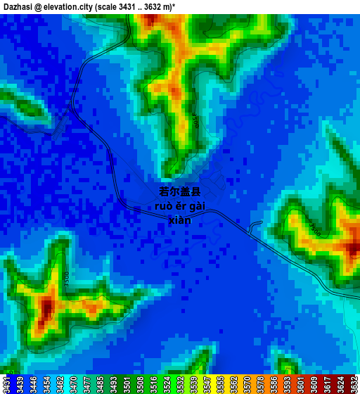
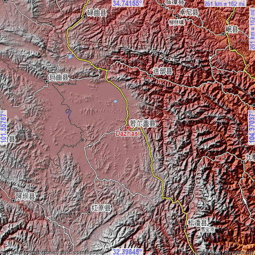
| \ | Map #1 | Topo.Map |
| Scale [m] | 3431..3632 m | × |
| Scale [ft] | 11257..11916 ft | × |
| Average | 3464.2 m = 11365 ft | × |
| Width | 8.14 km = 5.1 mi | 260.5 km = 161.9 mi |
| Height | 8.14 km = 5.1 mi | 260.5 km = 161.9 mi |
| ↑Max Latitude | 33.614555° | 34.74155° |
| Latitude at center | 33.57795° | 33.57795° |
| ↓Min Latitude | 33.54133° | 32.39845° |
| ← Min Longitude | 102.920175° | 101.55787° |
| Longitude center | 102.96412° | 102.96412° |
| →Max Longitude | 103.008065° | 104.37037° |
Nearby cities:
Cities around Dazhasi sort by population:
• Zhiqing Songduo elevation 3778 m
142.8 km,  263°
263°
• Dangchang Chengguanzhen 1722 m
142 km,  68°
68°
• Aba 3277 m
138.8 km,  237°
237°
• Chengjiao Chengguanzhen 2316 m
137 km,  45°
45°
• Zhouqu Chengguanzhen 1326 m
131.4 km,  79°
79°
• Lintan Chengguanzhen 2762 m
128.6 km,  16°
16°
• Liulin 2539 m
123 km, 23°
• Yongle 1416 m
122.8 km,  106°
106°
• Jin’an 2851 m
119.8 km,  150°
150°
• Qiongxi 3493 m
95.7 km,  204°
204°
• Nyinma 3480 m
95 km,  299°
299°
• Dianga 2499 m
58.7 km, 23°
Multilingual:
 En español:
Dazhasi elevación 3446 m.
 En France:
Dazhasi élévation 3446 m.
 Auf Deutsch:
Dazhasi höhe über dem Meeresspiegel ist 3446 m.

Sources and notes:
- [note 1] Map square and city borders are not equal. Map elevation data is calculated only from area inside that square.
- [src 1] Elevation data from geonames database provided with same terms of usage.
- [src 2] The elevation map of Dazhasi is generated using elevation data from NASA's 3 arcsec (90m) resolution SRTM data.
- [src 3] Base (background) map © OpenStreetMap contributors tiles are generated by Geofabrik and OpenTopoMap.
Copyright & License:
This Dazhasi Elevation Map is licensed under CC BY-SA. You may reuse any part from this page, if you give a proper credit by linking to this URL:
 More info on terms of use page.