Lintan Chengguanzhen elevation
Lintan Chengguanzhen (Gansu), China elevation is 2762 meters and Lintan Chengguanzhen elevation in feet is 9062 ft above sea level [src 1]. Lintan Chengguanzhen is a seat of a third-order administrative division (feature code) with elevation that is 2204 meters (7231 ft) bigger than average city elevation in China.
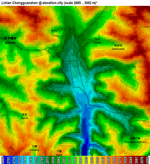
Below is the Elevation map of Lintan Chengguanzhen, which displays elevation range with different colors. Scale of the first map is from 2685 to 3092 m (8809 to 10144 ft) with average elevation of 2894.4 meters (=9496 ft) [note 1]
These maps also provides idea of topography and contour of this city, they are displayed at different zoom levels. More info about maps, scale and edge coordinates you can find below images.
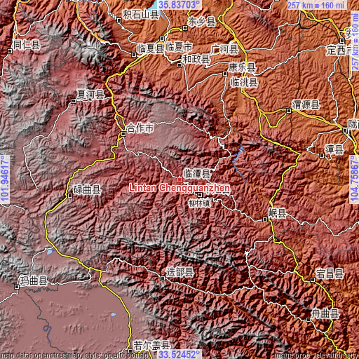
| \ | Map #1 | Topo.Map |
| Scale [m] | 2685..3092 m | × |
| Scale [ft] | 8809..10144 ft | × |
| Average | 2894.4 m = 9496 ft | × |
| Width | 8.04 km = 5 mi | 257.1 km = 159.8 mi |
| Height | 8.04 km = 5 mi | 257.1 km = 159.8 mi |
| ↑Max Latitude | 34.724976° | 35.83703° |
| Latitude at center | 34.68885° | 34.68885° |
| ↓Min Latitude | 34.652708° | 33.52452° |
| ← Min Longitude | 103.308475° | 101.94617° |
| Longitude center | 103.35242° | 103.35242° |
| →Max Longitude | 103.396365° | 104.75867° |
Nearby cities:
Cities around Lintan Chengguanzhen sort by population:
• Linxia Chengguanzhen elevation 1893 m
102.2 km,  352°
352°
• Hanji 2159 m
95.5 km,  339°
339°
• Labuleng 2926 m
94.8 km,  306°
306°
• Qingyuan 2071 m
93.6 km,  57°
57°
• Taoyang 1870 m
91.4 km,  29°
29°
• Guanghe Chengguanzhen 1954 m
90.5 km,  12°
12°
• Fucheng 2004 m
82.5 km,  22°
22°
• Hezheng Chengguanzhen 2103 m
82.4 km,  0°
0°
• Dianga 2499 m
70.7 km,  190°
190°
• Chengjiao Chengguanzhen 2316 m
68.2 km,  114°
114°
• Hezuo 2898 m
52.2 km, 309°
• Liulin 2539 m
17.7 km,  128°
128°
Multilingual:
 En español:
Lintan Chengguanzhen elevación 2762 m.
 En France:
Lintan Chengguanzhen élévation 2762 m.
 Auf Deutsch:
Lintan Chengguanzhen höhe über dem Meeresspiegel ist 2762 m.
 На русском:
Lintan Chengguanzhen высота над уровнем моря 2762 м
Sources and notes:
- [note 1] Map square and city borders are not equal. Map elevation data is calculated only from area inside that square.
- [src 1] Elevation data from geonames database provided with same terms of usage.
- [src 2] The elevation map of Lintan Chengguanzhen is generated using elevation data from NASA's 3 arcsec (90m) resolution SRTM data.
- [src 3] Base (background) map © OpenStreetMap contributors tiles are generated by Geofabrik and OpenTopoMap.
Copyright & License:
This Lintan Chengguanzhen Elevation Map is licensed under CC BY-SA. You may reuse any part from this page, if you give a proper credit by linking to this URL:
 More info on terms of use page.