Hezuo elevation
Hezuo (Gansu), China elevation is 2898 meters and Hezuo elevation in feet is 9508 ft above sea level [src 1]. Hezuo is a seat of a third-order administrative division (feature code) with elevation that is 2340 meters (7677 ft) bigger than average city elevation in China.
Below is the Elevation map of Hezuo, which displays elevation range with different colors. Scale of the first map is from 2850 to 3148 m (9350 to 10328 ft) with average elevation of 2971.1 meters (=9748 ft) [note 1]
These maps also provides idea of topography and contour of this city, they are displayed at different zoom levels. More info about maps, scale and edge coordinates you can find below images.
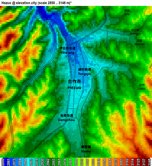
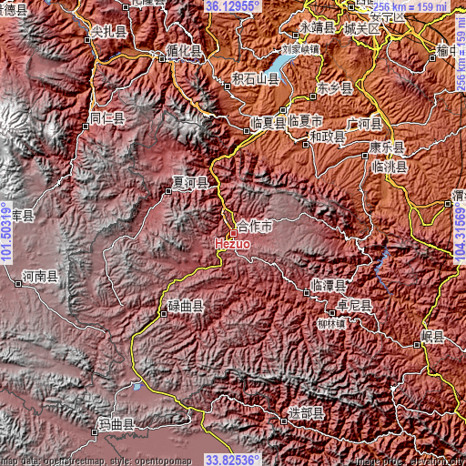
| \ | Map #1 | Topo.Map |
| Scale [m] | 2850..3148 m | × |
| Scale [ft] | 9350..10328 ft | × |
| Average | 2971.1 m = 9748 ft | × |
| Width | 8.01 km = 5 mi | 256.2 km = 159.2 mi |
| Height | 8.01 km = 5 mi | 256.2 km = 159.2 mi |
| ↑Max Latitude | 35.021556° | 36.12955° |
| Latitude at center | 34.98556° | 34.98556° |
| ↓Min Latitude | 34.949548° | 33.82536° |
| ← Min Longitude | 102.865495° | 101.50319° |
| Longitude center | 102.90944° | 102.90944° |
| →Max Longitude | 102.953385° | 104.31569° |
Nearby cities:
Cities around Hezuo sort by population:
• Linxia Chengguanzhen elevation 1893 m
73.5 km,  21°
21°
• Rongwo 2506 m
100.2 km,  305°
305°
• Taoyang 1870 m
97.4 km,  61°
61°
• Suonan 2393 m
87.7 km,  30°
30°
• Fucheng 2004 m
84.2 km, 59°
• Guanghe Chengguanzhen 1954 m
81.9 km,  47°
47°
• Chuimatan 2291 m
81.5 km,  357°
357°
• Liulin 2539 m
69.9 km,  129°
129°
• Hezheng Chengguanzhen 2103 m
64 km,  39°
39°
• Hanji 2159 m
57.2 km,  7°
7°
• Lintan Chengguanzhen 2762 m
52.2 km, 129°
• Labuleng 2926 m
42.7 km,  304°
304°
Multilingual:
 En español:
Hezuo elevación 2898 m.
 En France:
Hezuo élévation 2898 m.


Sources and notes:
- [note 1] Map square and city borders are not equal. Map elevation data is calculated only from area inside that square.
- [src 1] Elevation data from geonames database provided with same terms of usage.
- [src 2] The elevation map of Hezuo is generated using elevation data from NASA's 3 arcsec (90m) resolution SRTM data.
- [src 3] Base (background) map © OpenStreetMap contributors tiles are generated by Geofabrik and OpenTopoMap.
Copyright & License:
This Hezuo Elevation Map is licensed under CC BY-SA. You may reuse any part from this page, if you give a proper credit by linking to this URL:
 More info on terms of use page.