Dianga elevation
Dianga (Gansu), China elevation is 2499 meters and Dianga elevation in feet is 8199 ft above sea level [src 1]. Dianga is a seat of a third-order administrative division (feature code) with elevation that is 1941 meters (6368 ft) bigger than average city elevation in China.
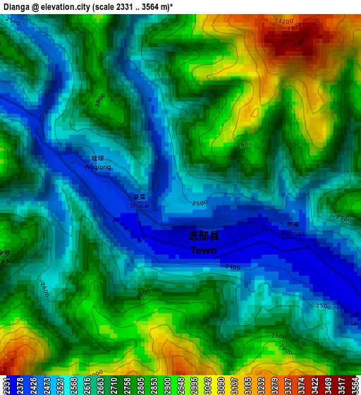
Below is the Elevation map of Dianga, which displays elevation range with different colors. Scale of the first map is from 2331 to 3564 m (7648 to 11693 ft) with average elevation of 2709 meters (=8888 ft) [note 1]
These maps also provides idea of topography and contour of this city, they are displayed at different zoom levels. More info about maps, scale and edge coordinates you can find below images.
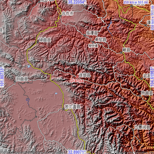
| \ | Map #1 | Topo.Map |
| Scale [m] | 2331..3564 m | × |
| Scale [ft] | 7648..11693 ft | × |
| Average | 2709 m = 8888 ft | × |
| Width | 8.1 km = 5 mi | 259.1 km = 161 mi |
| Height | 8.1 km = 5 mi | 259.1 km = 161 mi |
| ↑Max Latitude | 34.100027° | 35.22054° |
| Latitude at center | 34.06363° | 34.06363° |
| ↓Min Latitude | 34.027217° | 32.89071° |
| ← Min Longitude | 103.169635° | 101.80733° |
| Longitude center | 103.21358° | 103.21358° |
| →Max Longitude | 103.257525° | 104.61983° |
Nearby cities:
Cities around Dianga sort by population:
• Fucheng elevation 2004 m
152.3 km,  17°
17°
• Qingyuan 2071 m
150.9 km,  37°
37°
• Labuleng 2926 m
141.5 km,  333°
333°
• Yongle 1416 m
129.6 km,  133°
133°
• Zhouqu Chengguanzhen 1326 m
110.5 km,  106°
106°
• Dangchang Chengguanzhen 1722 m
108.8 km,  91°
91°
• Hezuo 2898 m
106.2 km,  344°
344°
• Nyinma 3480 m
105.5 km,  266°
266°
• Chengjiao Chengguanzhen 2316 m
85.7 km,  61°
61°
• Lintan Chengguanzhen 2762 m
70.7 km,  10°
10°
• Liulin 2539 m
64.3 km, 24°
• Dazhasi 3446 m
58.7 km,  203°
203°
Multilingual:
 En español:
Dianga elevación 2499 m.
 En France:
Dianga élévation 2499 m.


Sources and notes:
- [note 1] Map square and city borders are not equal. Map elevation data is calculated only from area inside that square.
- [src 1] Elevation data from geonames database provided with same terms of usage.
- [src 2] The elevation map of Dianga is generated using elevation data from NASA's 3 arcsec (90m) resolution SRTM data.
- [src 3] Base (background) map © OpenStreetMap contributors tiles are generated by Geofabrik and OpenTopoMap.
Copyright & License:
This Dianga Elevation Map is licensed under CC BY-SA. You may reuse any part from this page, if you give a proper credit by linking to this URL:
 More info on terms of use page.