Long’an elevation
Long’an (Sichuan), China elevation is 873 meters and Long’an elevation in feet is 2864 ft above sea level [src 1]. Long’an is a seat of a third-order administrative division (feature code) with elevation that is 315 meters (1033 ft) bigger than average city elevation in China.
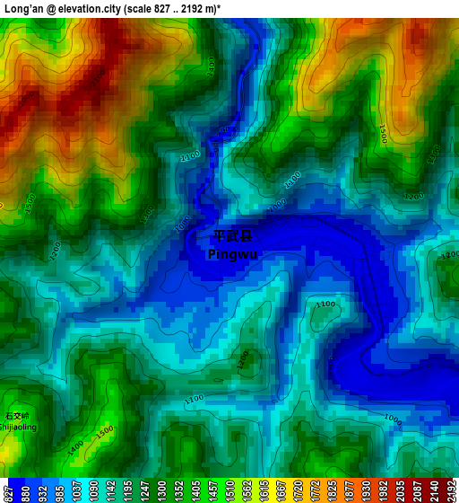
Below is the Elevation map of Long’an, which displays elevation range with different colors. Scale of the first map is from 827 to 2192 m (2713 to 7192 ft) with average elevation of 1248.6 meters (=4096 ft) [note 1]
These maps also provides idea of topography and contour of this city, they are displayed at different zoom levels. More info about maps, scale and edge coordinates you can find below images.
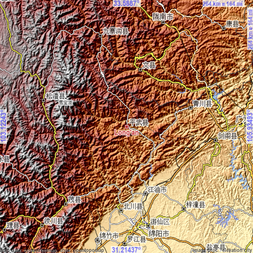
| \ | Map #1 | Topo.Map |
| Scale [m] | 827..2192 m | × |
| Scale [ft] | 2713..7192 ft | × |
| Average | 1248.6 m = 4096 ft | × |
| Width | 8.25 km = 5.1 mi | 264 km = 164 mi |
| Height | 8.25 km = 5.1 mi | 264 km = 164 mi |
| ↑Max Latitude | 32.446433° | 33.5887° |
| Latitude at center | 32.40934° | 32.40934° |
| ↓Min Latitude | 32.372232° | 31.21437° |
| ← Min Longitude | 104.484735° | 103.12243° |
| Longitude center | 104.52868° | 104.52868° |
| →Max Longitude | 104.572625° | 105.93493° |
Nearby cities:
Cities around Long’an sort by population:
• Mianyang elevation 471 m
105.7 km,  172°
172°
• Jiangyou 527 m
73.6 km, 166°
• Wenchang 484 m
104.3 km,  145°
145°
• Fengyi 1584 m
102.7 km,  218°
218°
• Yongle 1416 m
99 km,  343°
343°
• Huagai 518 m
96 km,  178°
178°
• Xiasi 578 m
93.4 km,  98°
98°
• Jin’an 2851 m
91 km,  286°
286°
• Yongchang 942 m
83.1 km,  185°
185°
• Zhongba 535 m
72.9 km,  164°
164°
• Qiaozhuang 800 m
69.1 km,  73°
73°
• Wenxian Chengguanzhen 1000 m
61.5 km,  13°
13°
Multilingual:
 En español:
Long’an elevación 873 m.
 En France:
Long’an élévation 873 m.


Sources and notes:
- [note 1] Map square and city borders are not equal. Map elevation data is calculated only from area inside that square.
- [src 1] Elevation data from geonames database provided with same terms of usage.
- [src 2] The elevation map of Long’an is generated using elevation data from NASA's 3 arcsec (90m) resolution SRTM data.
- [src 3] Base (background) map © OpenStreetMap contributors tiles are generated by Geofabrik and OpenTopoMap.
Copyright & License:
This Long’an Elevation Map is licensed under CC BY-SA. You may reuse any part from this page, if you give a proper credit by linking to this URL:
 More info on terms of use page.