Yongchang elevation
Yongchang (Sichuan), China elevation is 942 meters and Yongchang elevation in feet is 3091 ft above sea level [src 1]. Yongchang is a seat of a third-order administrative division (feature code) with elevation that is 384 meters (1260 ft) bigger than average city elevation in China.
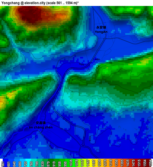
Below is the Elevation map of Yongchang, which displays elevation range with different colors. Scale of the first map is from 561 to 1594 m (1841 to 5230 ft) with average elevation of 763.8 meters (=2506 ft) [note 1]
These maps also provides idea of topography and contour of this city, they are displayed at different zoom levels. More info about maps, scale and edge coordinates you can find below images.
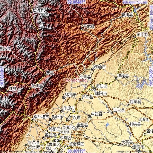
| \ | Map #1 | Topo.Map |
| Scale [m] | 561..1594 m | × |
| Scale [ft] | 1841..5230 ft | × |
| Average | 763.8 m = 2506 ft | × |
| Width | 8.32 km = 5.2 mi | 266.2 km = 165.4 mi |
| Height | 8.32 km = 5.2 mi | 266.2 km = 165.4 mi |
| ↑Max Latitude | 31.703135° | 32.85487° |
| Latitude at center | 31.66574° | 31.66574° |
| ↓Min Latitude | 31.62833° | 30.46119° |
| ← Min Longitude | 104.393315° | 103.03101° |
| Longitude center | 104.43726° | 104.43726° |
| →Max Longitude | 104.481205° | 105.84351° |
Nearby cities:
Cities around Yongchang sort by population:
• Mianyang elevation 471 m
31.9 km,  133°
133°
• Deyang 501 m
59.8 km,  185°
185°
• Jiangyou 527 m
28.7 km,  66°
66°
• Luocheng 482 m
77.7 km, 191°
• Kaijiang 431 m
73.2 km,  162°
162°
• Wenchang 484 m
68 km,  92°
92°
• Fangting 529 m
65.1 km,  203°
203°
• Fengyi 1584 m
55.2 km,  272°
272°
• Jiannan 600 m
42.5 km,  212°
212°
• Luojiang 509 m
40.6 km,  170°
170°
• Zhongba 535 m
31.2 km, 66°
• Huagai 518 m
17.4 km,  139°
139°
Multilingual:
 En español:
Yongchang elevación 942 m.
 En France:
Yongchang élévation 942 m.
 Auf Deutsch:
Yongchang höhe über dem Meeresspiegel ist 942 m.

Sources and notes:
- [note 1] Map square and city borders are not equal. Map elevation data is calculated only from area inside that square.
- [src 1] Elevation data from geonames database provided with same terms of usage.
- [src 2] The elevation map of Yongchang is generated using elevation data from NASA's 3 arcsec (90m) resolution SRTM data.
- [src 3] Base (background) map © OpenStreetMap contributors tiles are generated by Geofabrik and OpenTopoMap.
Copyright & License:
This Yongchang Elevation Map is licensed under CC BY-SA. You may reuse any part from this page, if you give a proper credit by linking to this URL:
 More info on terms of use page.