Monarch Mill elevation
Monarch Mill (South Carolina, Union County), United States elevation is 162 meters and Monarch Mill elevation in feet is 531 ft above sea level [src 1]. Monarch Mill is a populated place (feature code) with elevation that is 117 meters (384 ft) smaller than average city elevation in United States.
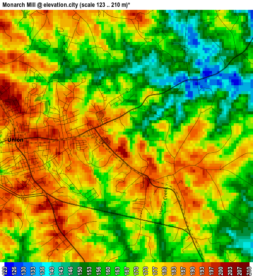
Below is the Elevation map of Monarch Mill, which displays elevation range with different colors. Scale of the first map is from 123 to 210 m (404 to 689 ft) with average elevation of 170.9 meters (=561 ft) [note 1]
These maps also provides idea of topography and contour of this city, they are displayed at different zoom levels. More info about maps, scale and edge coordinates you can find below images.
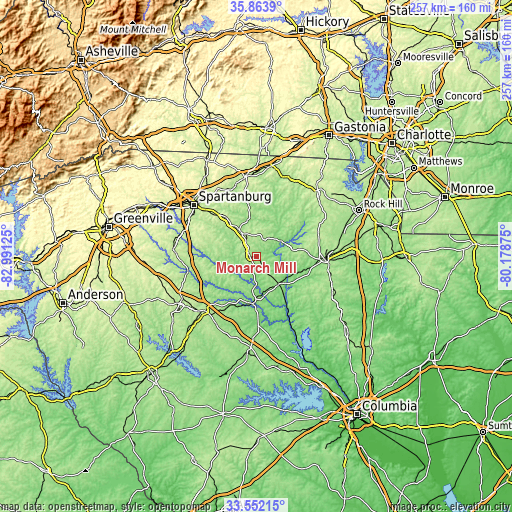
| \ | Map #1 | Topo.Map |
| Scale [m] | 123..210 m | × |
| Scale [ft] | 404..689 ft | × |
| Average | 170.9 m = 561 ft | × |
| Width | 8.03 km = 5 mi | 257 km = 159.7 mi |
| Height | 8.03 km = 5 mi | 257 km = 159.7 mi |
| ↑Max Latitude | 34.752214° | 35.8639° |
| Latitude at center | 34.7161° | 34.7161° |
| ↓Min Latitude | 34.67997° | 33.55215° |
| ← Min Longitude | -81.628945° | -82.99125° |
| Longitude center | -81.585° | -81.585° |
| →Max Longitude | -81.541055° | -80.17875° |
Nearby cities:
Cities around Monarch Mill sort by population:
• Gaffney elevation 241 m
40 km,  351°
351°
• Clinton 205 m
38.3 km,  224°
224°
• Union 197 m
3.5 km,  268°
268°
• Chester 163 m
33.9 km,  92°
92°
• East Gaffney 239 m
40.7 km, 353°
• Pacolet 238 m
26 km,  321°
321°
• Cowpens 263 m
38.9 km,  329°
329°
• Roebuck 230 m
39.3 km,  297°
297°
• Joanna 183 m
39.4 km,  211°
211°
• Eureka Mill 158 m
35.8 km, 89°
• Whitmire 133 m
23.8 km,  185°
185°
• Buffalo 184 m
9.1 km,  276°
276°
Multilingual:
 En español:
Monarch Mill elevación 162 m.
 En France:
Monarch Mill élévation 162 m.
 Auf Deutsch:
Monarch Mill höhe über dem Meeresspiegel ist 162 m.

Sources and notes:
- [note 1] Map square and city borders are not equal. Map elevation data is calculated only from area inside that square.
- [src 1] Elevation data from geonames database provided with same terms of usage.
- [src 2] The elevation map of Monarch Mill is generated using elevation data from NASA's 3 arcsec (90m) resolution SRTM data.
- [src 3] Base (background) map © OpenStreetMap contributors tiles are generated by Geofabrik and OpenTopoMap.
Copyright & License:
This Monarch Mill Elevation Map is licensed under CC BY-SA. You may reuse any part from this page, if you give a proper credit by linking to this URL:
 More info on terms of use page.