Joanna elevation
Joanna (South Carolina, Laurens County), United States elevation is 183 meters and Joanna elevation in feet is 600 ft above sea level [src 1]. Joanna is a populated place (feature code) with elevation that is 96 meters (315 ft) smaller than average city elevation in United States.
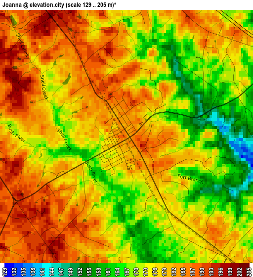
Below is the Elevation map of Joanna, which displays elevation range with different colors. Scale of the first map is from 129 to 205 m (423 to 673 ft) with average elevation of 176.7 meters (=580 ft) [note 1]
These maps also provides idea of topography and contour of this city, they are displayed at different zoom levels. More info about maps, scale and edge coordinates you can find below images.
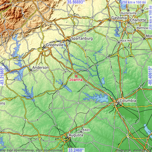
| \ | Map #1 | Topo.Map |
| Scale [m] | 129..205 m | × |
| Scale [ft] | 423..673 ft | × |
| Average | 176.7 m = 580 ft | × |
| Width | 8.06 km = 5 mi | 258 km = 160.3 mi |
| Height | 8.06 km = 5 mi | 258 km = 160.3 mi |
| ↑Max Latitude | 34.451156° | 35.56693° |
| Latitude at center | 34.41491° | 34.41491° |
| ↓Min Latitude | 34.378649° | 33.2468° |
| ← Min Longitude | -81.856345° | -83.21865° |
| Longitude center | -81.8124° | -81.8124° |
| →Max Longitude | -81.768455° | -80.40615° |
Nearby cities:
Cities around Joanna sort by population:
• Greenwood elevation 205 m
40.3 km,  232°
232°
• Newberry 152 m
23.7 km,  131°
131°
• Laurens 190 m
20.7 km,  296°
296°
• Clinton 205 m
9 km,  315°
315°
• Union 197 m
37.6 km,  27°
27°
• Ware Shoals 197 m
39.9 km,  267°
267°
• Ninety Six 167 m
33 km,  216°
216°
• Monarch Mill 162 m
39.4 km, 31°
• Watts Mills 205 m
19.5 km,  305°
305°
• Whitmire 133 m
20.9 km,  62°
62°
• Buffalo 184 m
36.5 km,  18°
18°
• Prosperity 166 m
34.4 km, 131°
Multilingual:
 En español:
Joanna elevación 183 m.
 En France:
Joanna élévation 183 m.


Sources and notes:
- [note 1] Map square and city borders are not equal. Map elevation data is calculated only from area inside that square.
- [src 1] Elevation data from geonames database provided with same terms of usage.
- [src 2] The elevation map of Joanna is generated using elevation data from NASA's 3 arcsec (90m) resolution SRTM data.
- [src 3] Base (background) map © OpenStreetMap contributors tiles are generated by Geofabrik and OpenTopoMap.
Copyright & License:
This Joanna Elevation Map is licensed under CC BY-SA. You may reuse any part from this page, if you give a proper credit by linking to this URL:
 More info on terms of use page.