Whitmire elevation
Whitmire (South Carolina, Newberry County), United States elevation is 133 meters and Whitmire elevation in feet is 436 ft above sea level [src 1]. Whitmire is a populated place (feature code) with elevation that is 146 meters (479 ft) smaller than average city elevation in United States.
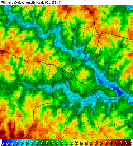
Below is the Elevation map of Whitmire, which displays elevation range with different colors. Scale of the first map is from 90 to 175 m (295 to 574 ft) with average elevation of 131.5 meters (=431 ft) [note 1]
These maps also provides idea of topography and contour of this city, they are displayed at different zoom levels. More info about maps, scale and edge coordinates you can find below images.
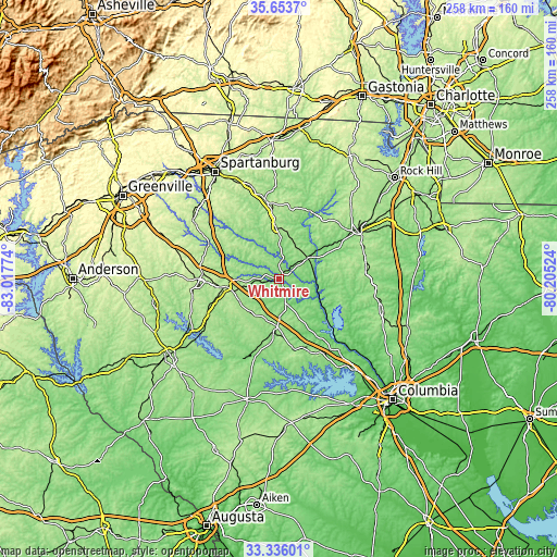
| \ | Map #1 | Topo.Map |
| Scale [m] | 90..175 m | × |
| Scale [ft] | 295..574 ft | × |
| Average | 131.5 m = 431 ft | × |
| Width | 8.05 km = 5 mi | 257.7 km = 160.1 mi |
| Height | 8.05 km = 5 mi | 257.7 km = 160.1 mi |
| ↑Max Latitude | 34.539117° | 35.6537° |
| Latitude at center | 34.50291° | 34.50291° |
| ↓Min Latitude | 34.466687° | 33.33601° |
| ← Min Longitude | -81.655435° | -83.01774° |
| Longitude center | -81.61149° | -81.61149° |
| →Max Longitude | -81.567545° | -80.20524° |
Nearby cities:
Cities around Whitmire sort by population:
• Newberry elevation 152 m
25.4 km,  181°
181°
• Laurens 190 m
36.9 km,  269°
269°
• Clinton 205 m
24.9 km,  262°
262°
• Union 197 m
23.7 km,  357°
357°
• Chester 163 m
42.7 km,  58°
58°
• Monarch Mill 162 m
23.8 km,  5°
5°
• Watts Mills 205 m
34.3 km, 272°
• Chapin 139 m
44.5 km,  147°
147°
• Joanna 183 m
20.9 km,  242°
242°
• Eureka Mill 158 m
45.1 km, 58°
• Buffalo 184 m
25.6 km,  345°
345°
• Prosperity 166 m
33.4 km,  167°
167°
Multilingual:
 En español:
Whitmire elevación 133 m.
 En France:
Whitmire élévation 133 m.
 Auf Deutsch:
Whitmire höhe über dem Meeresspiegel ist 133 m.

Sources and notes:
- [note 1] Map square and city borders are not equal. Map elevation data is calculated only from area inside that square.
- [src 1] Elevation data from geonames database provided with same terms of usage.
- [src 2] The elevation map of Whitmire is generated using elevation data from NASA's 3 arcsec (90m) resolution SRTM data.
- [src 3] Base (background) map © OpenStreetMap contributors tiles are generated by Geofabrik and OpenTopoMap.
Copyright & License:
This Whitmire Elevation Map is licensed under CC BY-SA. You may reuse any part from this page, if you give a proper credit by linking to this URL:
 More info on terms of use page.