Chester elevation
Chester (South Carolina, Chester County), United States elevation is 163 meters and Chester elevation in feet is 535 ft above sea level [src 1]. Chester is a seat of a second-order administrative division (feature code) with elevation that is 116 meters (381 ft) smaller than average city elevation in United States.
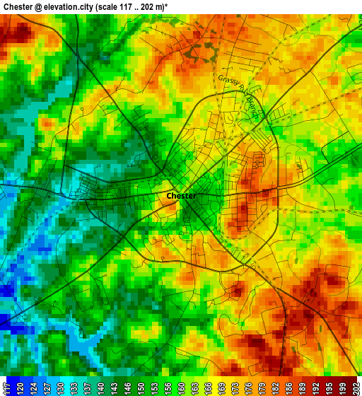
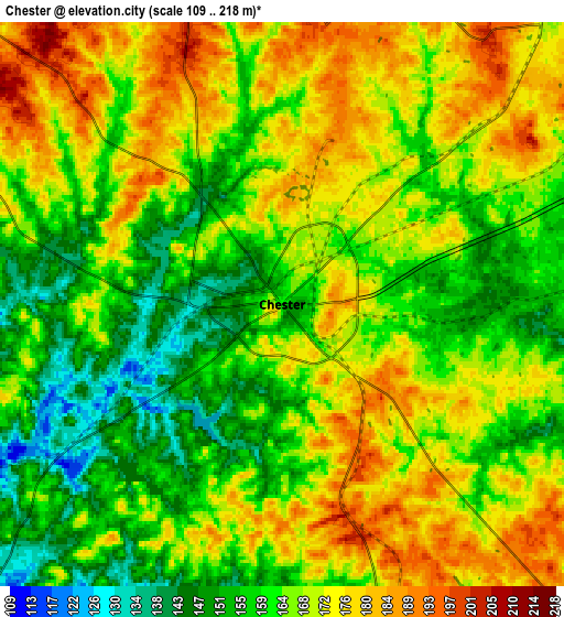
Below is the Elevation map of Chester, which displays elevation range with different colors. Scale of the first map is from 117 to 202 m (384 to 663 ft) with average elevation of 160.9 meters (=528 ft) [note 1]
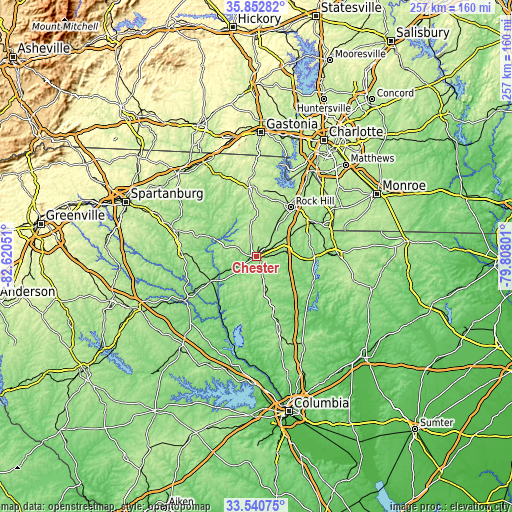
These maps also provides idea of topography and contour of this city, they are displayed at different zoom levels. More info about maps, scale and edge coordinates you can find below images.
| \ | Map #1 | Map #2 | Topo.Map |
| Scale [m] | 117..202 m | 109..218 m | × |
| Scale [ft] | 384..663 ft | 358..715 ft | × |
| Average | 160.9 m = 528 ft | 165.9 m = 544 ft | × |
| Width | 8.03 km = 5 mi | 16.07 km = 10 mi | 257.1 km = 159.8 mi |
| Height | 8.03 km = 5 mi | 16.07 km = 10 mi | 257.1 km = 159.8 mi |
| ↑Max Latitude | 34.740979° | 34.777083° | 35.85282° |
| Latitude at center | 34.70486° | 34.70486° | 34.70486° |
| ↓Min Latitude | 34.668725° | 34.632574° | 33.54075° |
| ← Min Longitude | -81.258205° | -81.302151° | -82.62051° |
| Longitude center | -81.21426° | -81.21426° | -81.21426° |
| →Max Longitude | -81.170315° | -81.126369° | -79.80801° |
Nearby cities:
Cities around Chester sort by population:
• Rock Hill elevation 209 m
29.9 km,  35°
35°
• Union 197 m
37.4 km,  271°
271°
• York 233 m
32.3 km,  355°
355°
• Newport 217 m
33.3 km,  18°
18°
• Winnsboro 164 m
37.9 km,  162°
162°
• India Hook 196 m
37.9 km,  27°
27°
• Lesslie 212 m
31.3 km,  48°
48°
• Great Falls 141 m
32 km,  116°
116°
• Monarch Mill 162 m
33.9 km, 272°
• Eureka Mill 158 m
2.4 km, 52°
• Irwin 152 m
35.9 km,  91°
91°
• Catawba 170 m
32.2 km,  59°
59°
Multilingual:
 En español:
Chester elevación 163 m.
 En France:
Chester élévation 163 m.


Sources and notes:
- [note 1] Map square and city borders are not equal. Map elevation data is calculated only from area inside that square.
- [src 1] Elevation data from geonames database provided with same terms of usage.
- [src 2] The elevation map of Chester is generated using elevation data from NASA's 3 arcsec (90m) resolution SRTM data.
- [src 3] Base (background) map © OpenStreetMap contributors tiles are generated by Geofabrik and OpenTopoMap.
Copyright & License:
This Chester Elevation Map is licensed under CC BY-SA. You may reuse any part from this page, if you give a proper credit by linking to this URL:
 More info on terms of use page.