East Gaffney elevation
East Gaffney (South Carolina, Cherokee County), United States elevation is 239 meters and East Gaffney elevation in feet is 784 ft above sea level [src 1]. East Gaffney is a populated place (feature code) with elevation that is 40 meters (131 ft) smaller than average city elevation in United States.
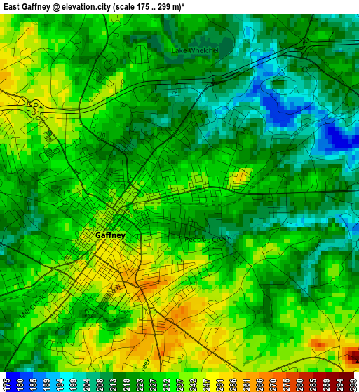
Below is the Elevation map of East Gaffney, which displays elevation range with different colors. Scale of the first map is from 175 to 299 m (574 to 981 ft) with average elevation of 226.9 meters (=744 ft) [note 1]
These maps also provides idea of topography and contour of this city, they are displayed at different zoom levels. More info about maps, scale and edge coordinates you can find below images.
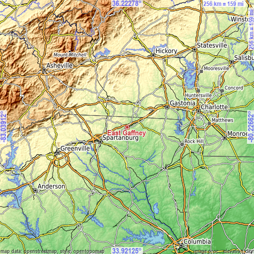
| \ | Map #1 | Topo.Map |
| Scale [m] | 175..299 m | × |
| Scale [ft] | 574..981 ft | × |
| Average | 226.9 m = 744 ft | × |
| Width | 8 km = 5 mi | 255.9 km = 159 mi |
| Height | 8 km = 5 mi | 255.9 km = 159 mi |
| ↑Max Latitude | 35.116085° | 36.22278° |
| Latitude at center | 35.08013° | 35.08013° |
| ↓Min Latitude | 35.044159° | 33.92125° |
| ← Min Longitude | -81.676815° | -83.03912° |
| Longitude center | -81.63287° | -81.63287° |
| →Max Longitude | -81.588925° | -80.22662° |
Nearby cities:
Cities around East Gaffney sort by population:
• Spartanburg elevation 248 m
30.9 km,  241°
241°
• Shelby 266 m
25.2 km,  20°
20°
• Gaffney 241 m
1.8 km, 238°
• Kings Mountain 307 m
32.2 km,  55°
55°
• Boiling Springs 285 m
32 km,  263°
263°
• Valley Falls 246 m
31.9 km, 257°
• Boiling Springs 272 m
19.6 km,  350°
350°
• Pacolet 238 m
23.3 km,  210°
210°
• Cowpens 263 m
17.1 km,  245°
245°
• Blacksburg 233 m
11.6 km,  66°
66°
• Mayo 272 m
20.7 km,  271°
271°
• White Plains 272 m
27.4 km,  51°
51°
Multilingual:
 En español:
East Gaffney elevación 239 m.
 En France:
East Gaffney élévation 239 m.
 Auf Deutsch:
East Gaffney höhe über dem Meeresspiegel ist 239 m.

Sources and notes:
- [note 1] Map square and city borders are not equal. Map elevation data is calculated only from area inside that square.
- [src 1] Elevation data from geonames database provided with same terms of usage.
- [src 2] The elevation map of East Gaffney is generated using elevation data from NASA's 3 arcsec (90m) resolution SRTM data.
- [src 3] Base (background) map © OpenStreetMap contributors tiles are generated by Geofabrik and OpenTopoMap.
Copyright & License:
This East Gaffney Elevation Map is licensed under CC BY-SA. You may reuse any part from this page, if you give a proper credit by linking to this URL:
 More info on terms of use page.