Roebuck elevation
Roebuck (South Carolina, Spartanburg County), United States elevation is 230 meters and Roebuck elevation in feet is 755 ft above sea level [src 1]. Roebuck is a populated place (feature code) with elevation that is 49 meters (161 ft) smaller than average city elevation in United States.
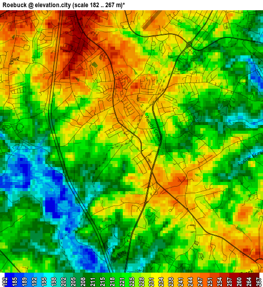
Below is the Elevation map of Roebuck, which displays elevation range with different colors. Scale of the first map is from 182 to 267 m (597 to 876 ft) with average elevation of 224.4 meters (=736 ft) [note 1]
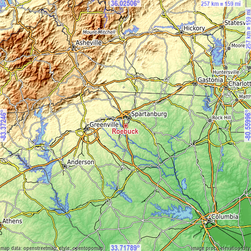
These maps also provides idea of topography and contour of this city, they are displayed at different zoom levels. More info about maps, scale and edge coordinates you can find below images.
| \ | Map #1 | Topo.Map |
| Scale [m] | 182..267 m | × |
| Scale [ft] | 597..876 ft | × |
| Average | 224.4 m = 736 ft | × |
| Width | 8.02 km = 5 mi | 256.5 km = 159.4 mi |
| Height | 8.02 km = 5 mi | 256.5 km = 159.4 mi |
| ↑Max Latitude | 34.915613° | 36.02506° |
| Latitude at center | 34.87957° | 34.87957° |
| ↓Min Latitude | 34.843511° | 33.71789° |
| ← Min Longitude | -82.010155° | -83.37246° |
| Longitude center | -81.96621° | -81.96621° |
| →Max Longitude | -81.922265° | -80.55996° |
Nearby cities:
Cities around Roebuck sort by population:
• Spartanburg elevation 248 m
8.4 km,  21°
21°
• Boiling Springs 285 m
18.6 km,  355°
355°
• Valley Falls 246 m
15.2 km, 357°
• Woodruff 243 m
16.9 km,  202°
202°
• Southern Shops 276 m
12.1 km,  347°
347°
• Saxon 263 m
9.1 km, 359°
• Lyman 260 m
16.6 km,  297°
297°
• Duncan 264 m
17.6 km,  291°
291°
• Arcadia 250 m
9 km, 345°
• Wellford 267 m
15 km, 301°
• Pacolet 238 m
18.8 km,  83°
83°
• Fairforest 259 m
9.4 km,  334°
334°
Multilingual:
 En español:
Roebuck elevación 230 m.
 En France:
Roebuck élévation 230 m.


Sources and notes:
- [note 1] Map square and city borders are not equal. Map elevation data is calculated only from area inside that square.
- [src 1] Elevation data from geonames database provided with same terms of usage.
- [src 2] The elevation map of Roebuck is generated using elevation data from NASA's 3 arcsec (90m) resolution SRTM data.
- [src 3] Base (background) map © OpenStreetMap contributors tiles are generated by Geofabrik and OpenTopoMap.
Copyright & License:
This Roebuck Elevation Map is licensed under CC BY-SA. You may reuse any part from this page, if you give a proper credit by linking to this URL:
 More info on terms of use page.