Madera elevation
Madera (California, Madera County), United States elevation is 87 meters and Madera elevation in feet is 285 ft above sea level [src 1]. Madera is a seat of a second-order administrative division (feature code) with elevation that is 192 meters (630 ft) smaller than average city elevation in United States.
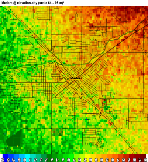
Below is the Elevation map of Madera, which displays elevation range with different colors. Scale of the first map is from 64 to 98 m (210 to 322 ft) with average elevation of 84.2 meters (=276 ft) [note 1]
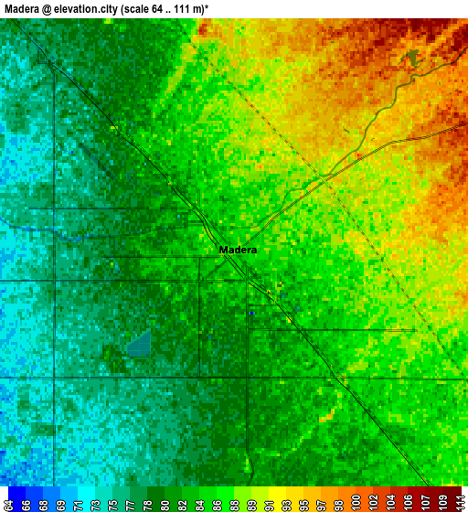
These maps also provides idea of topography and contour of this city, they are displayed at different zoom levels. More info about maps, scale and edge coordinates you can find below images.
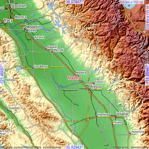
| \ | Map #1 | Map #2 | Topo.Map |
| Scale [m] | 64..98 m | 64..111 m | × |
| Scale [ft] | 210..322 ft | 210..364 ft | × |
| Average | 84.2 m = 276 ft | 84 m = 276 ft | × |
| Width | 7.81 km = 4.9 mi | 15.62 km = 9.7 mi | 249.9 km = 155.3 mi |
| Height | 7.81 km = 4.9 mi | 15.62 km = 9.7 mi | 249.9 km = 155.3 mi |
| ↑Max Latitude | 36.996446° | 37.031536° | 38.07667° |
| Latitude at center | 36.96134° | 36.96134° | 36.96134° |
| ↓Min Latitude | 36.926218° | 36.891079° | 35.82943° |
| ← Min Longitude | -120.104665° | -120.148611° | -121.46697° |
| Longitude center | -120.06072° | -120.06072° | -120.06072° |
| →Max Longitude | -120.016775° | -119.972829° | -118.65447° |
Nearby cities:
Cities around Madera sort by population:
• Fresno elevation 99 m
35 km,  132°
132°
• Chowchilla 75 m
25.2 km,  315°
315°
• Kerman 72 m
26.4 km,  179°
179°
• Madera Acres 88 m
6.4 km,  355°
355°
• Bonadelle Ranchos-Madera Ranchos 116 m
16.7 km,  81°
81°
• Old Fig Garden 100 m
29 km, 128°
• Parksdale 86 m
3.7 km,  115°
115°
• Parkwood 83 m
4.1 km,  159°
159°
• Le Grand 81 m
34 km,  330°
330°
• Biola 79 m
18.1 km,  167°
167°
• Fairmead 77 m
17.4 km, 317°
• West Park 81 m
33.6 km,  146°
146°
Multilingual:
 En español:
Madera elevación 87 m.
 En France:
Madera élévation 87 m.


Sources and notes:
- [note 1] Map square and city borders are not equal. Map elevation data is calculated only from area inside that square.
- [src 1] Elevation data from geonames database provided with same terms of usage.
- [src 2] The elevation map of Madera is generated using elevation data from NASA's 3 arcsec (90m) resolution SRTM data.
- [src 3] Base (background) map © OpenStreetMap contributors tiles are generated by Geofabrik and OpenTopoMap.
Copyright & License:
This Madera Elevation Map is licensed under CC BY-SA. You may reuse any part from this page, if you give a proper credit by linking to this URL:
 More info on terms of use page.