Kerman elevation
Kerman (California, Fresno County), United States elevation is 72 meters and Kerman elevation in feet is 236 ft above sea level [src 1]. Kerman is a populated place (feature code) with elevation that is 207 meters (679 ft) smaller than average city elevation in United States.
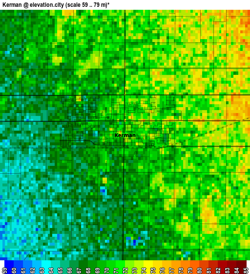
Below is the Elevation map of Kerman, which displays elevation range with different colors. Scale of the first map is from 59 to 79 m (194 to 259 ft) with average elevation of 69.2 meters (=227 ft) [note 1]
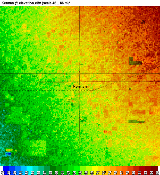
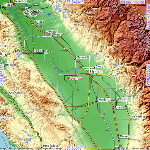
These maps also provides idea of topography and contour of this city, they are displayed at different zoom levels. More info about maps, scale and edge coordinates you can find below images.
| \ | Map #1 | Map #2 | Topo.Map |
| Scale [m] | 59..79 m | 46..86 m | × |
| Scale [ft] | 194..259 ft | 151..282 ft | × |
| Average | 69.2 m = 227 ft | 69.2 m = 227 ft | × |
| Width | 7.83 km = 4.9 mi | 15.67 km = 9.7 mi | 250.6 km = 155.7 mi |
| Height | 7.83 km = 4.9 mi | 15.67 km = 9.7 mi | 250.6 km = 155.7 mi |
| ↑Max Latitude | 36.758775° | 36.793975° | 37.84241° |
| Latitude at center | 36.72356° | 36.72356° | 36.72356° |
| ↓Min Latitude | 36.688328° | 36.653081° | 35.58817° |
| ← Min Longitude | -120.103825° | -120.147771° | -121.46613° |
| Longitude center | -120.05988° | -120.05988° | -120.05988° |
| →Max Longitude | -120.015935° | -119.971989° | -118.65363° |
Nearby cities:
Cities around Kerman sort by population:
• Fresno elevation 99 m
25.8 km,  84°
84°
• Madera 87 m
26.4 km,  359°
359°
• Mendota 53 m
28.9 km,  276°
276°
• Old Fig Garden 100 m
24.2 km,  69°
69°
• Sunnyside 101 m
32.3 km, 84°
• San Joaquin 56 m
17.4 km,  221°
221°
• Parksdale 86 m
25.1 km,  7°
7°
• Caruthers 78 m
28.5 km,  134°
134°
• Parkwood 83 m
22.6 km,  3°
3°
• Easton 89 m
25.3 km,  108°
108°
• Biola 79 m
9.6 km,  23°
23°
• West Park 81 m
18.7 km,  94°
94°
Multilingual:
 En español:
Kerman elevación 72 m.
 En France:
Kerman élévation 72 m.


Sources and notes:
- [note 1] Map square and city borders are not equal. Map elevation data is calculated only from area inside that square.
- [src 1] Elevation data from geonames database provided with same terms of usage.
- [src 2] The elevation map of Kerman is generated using elevation data from NASA's 3 arcsec (90m) resolution SRTM data.
- [src 3] Base (background) map © OpenStreetMap contributors tiles are generated by Geofabrik and OpenTopoMap.
Copyright & License:
This Kerman Elevation Map is licensed under CC BY-SA. You may reuse any part from this page, if you give a proper credit by linking to this URL:
 More info on terms of use page.