West Park elevation
West Park (California, Fresno County), United States elevation is 81 meters and West Park elevation in feet is 266 ft above sea level [src 1]. West Park is a populated place (feature code) with elevation that is 198 meters (650 ft) smaller than average city elevation in United States.
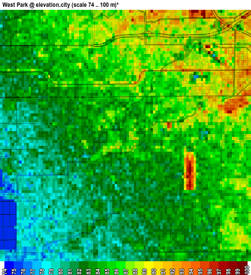
Below is the Elevation map of West Park, which displays elevation range with different colors. Scale of the first map is from 74 to 100 m (243 to 328 ft) with average elevation of 83.9 meters (=275 ft) [note 1]
These maps also provides idea of topography and contour of this city, they are displayed at different zoom levels. More info about maps, scale and edge coordinates you can find below images.
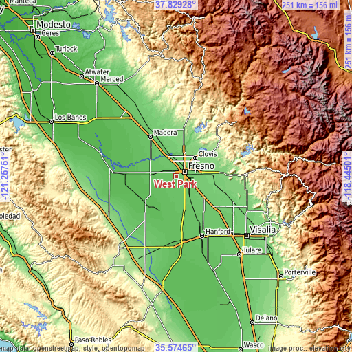
| \ | Map #1 | Topo.Map |
| Scale [m] | 74..100 m | × |
| Scale [ft] | 243..328 ft | × |
| Average | 83.9 m = 275 ft | × |
| Width | 7.83 km = 4.9 mi | 250.7 km = 155.8 mi |
| Height | 7.83 km = 4.9 mi | 250.7 km = 155.8 mi |
| ↑Max Latitude | 36.745452° | 37.82928° |
| Latitude at center | 36.71023° | 36.71023° |
| ↓Min Latitude | 36.674992° | 35.57465° |
| ← Min Longitude | -119.895205° | -121.25751° |
| Longitude center | -119.85126° | -119.85126° |
| →Max Longitude | -119.807315° | -118.44501° |
Nearby cities:
Cities around West Park sort by population:
• Fresno elevation 99 m
8.2 km,  59°
59°
• Clovis 113 m
18.4 km,  45°
45°
• Sanger 115 m
26.3 km,  90°
90°
• Kerman 72 m
18.7 km,  274°
274°
• Fowler 97 m
17.8 km,  119°
119°
• Old Fig Garden 100 m
10.7 km,  22°
22°
• Sunnyside 101 m
14.2 km,  72°
72°
• Tarpey Village 111 m
16.2 km, 55°
• Caruthers 78 m
18.7 km,  175°
175°
• Easton 89 m
8.6 km,  141°
141°
• Del Rey 105 m
23.7 km,  103°
103°
• Biola 79 m
17.9 km,  304°
304°
Multilingual:
 En español:
West Park elevación 81 m.
 En France:
West Park élévation 81 m.
 Auf Deutsch:
West Park höhe über dem Meeresspiegel ist 81 m.

Sources and notes:
- [note 1] Map square and city borders are not equal. Map elevation data is calculated only from area inside that square.
- [src 1] Elevation data from geonames database provided with same terms of usage.
- [src 2] The elevation map of West Park is generated using elevation data from NASA's 3 arcsec (90m) resolution SRTM data.
- [src 3] Base (background) map © OpenStreetMap contributors tiles are generated by Geofabrik and OpenTopoMap.
Copyright & License:
This West Park Elevation Map is licensed under CC BY-SA. You may reuse any part from this page, if you give a proper credit by linking to this URL:
 More info on terms of use page.