Le Grand elevation
Le Grand (California, Merced County), United States elevation is 81 meters and Le Grand elevation in feet is 266 ft above sea level [src 1]. Le Grand is a populated place (feature code) with elevation that is 198 meters (650 ft) smaller than average city elevation in United States.
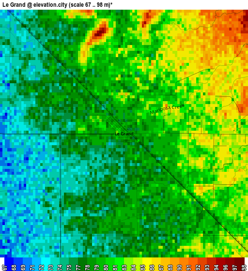
Below is the Elevation map of Le Grand, which displays elevation range with different colors. Scale of the first map is from 67 to 98 m (220 to 322 ft) with average elevation of 79.1 meters (=260 ft) [note 1]
These maps also provides idea of topography and contour of this city, they are displayed at different zoom levels. More info about maps, scale and edge coordinates you can find below images.
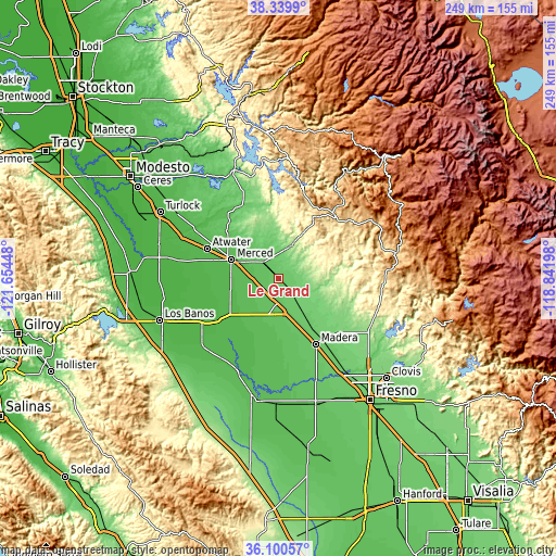
| \ | Map #1 | Topo.Map |
| Scale [m] | 67..98 m | × |
| Scale [ft] | 220..322 ft | × |
| Average | 79.1 m = 260 ft | × |
| Width | 7.78 km = 4.8 mi | 249 km = 154.7 mi |
| Height | 7.78 km = 4.8 mi | 249 km = 154.7 mi |
| ↑Max Latitude | 37.263532° | 38.3399° |
| Latitude at center | 37.22855° | 37.22855° |
| ↓Min Latitude | 37.193551° | 36.10057° |
| ← Min Longitude | -120.292175° | -121.65448° |
| Longitude center | -120.24823° | -120.24823° |
| →Max Longitude | -120.204285° | -118.84198° |
Nearby cities:
Cities around Le Grand sort by population:
• Merced elevation 56 m
22.3 km,  291°
291°
• Madera 87 m
34 km,  150°
150°
• Atwater 50 m
34.6 km, 292°
• Chowchilla 75 m
11.8 km,  185°
185°
• Winton 59 m
36.9 km,  298°
298°
• Madera Acres 88 m
28.3 km, 145°
• Yosemite Lakes 393 m
42.3 km,  95°
95°
• Planada 72 m
9.3 km,  318°
318°
• Parksdale 86 m
37.1 km, 147°
• Parkwood 83 m
38.1 km, 151°
• Mariposa 590 m
37.9 km,  41°
41°
• Fairmead 77 m
17.6 km,  163°
163°
Multilingual:
 En español:
Le Grand elevación 81 m.
 En France:
Le Grand élévation 81 m.


Sources and notes:
- [note 1] Map square and city borders are not equal. Map elevation data is calculated only from area inside that square.
- [src 1] Elevation data from geonames database provided with same terms of usage.
- [src 2] The elevation map of Le Grand is generated using elevation data from NASA's 3 arcsec (90m) resolution SRTM data.
- [src 3] Base (background) map © OpenStreetMap contributors tiles are generated by Geofabrik and OpenTopoMap.
Copyright & License:
This Le Grand Elevation Map is licensed under CC BY-SA. You may reuse any part from this page, if you give a proper credit by linking to this URL:
 More info on terms of use page.