Chowchilla elevation
Chowchilla (California, Madera County), United States elevation is 75 meters and Chowchilla elevation in feet is 246 ft above sea level [src 1]. Chowchilla is a populated place (feature code) with elevation that is 204 meters (669 ft) smaller than average city elevation in United States.
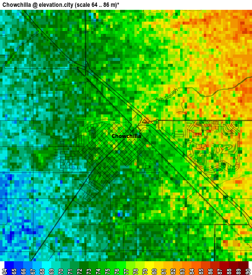
Below is the Elevation map of Chowchilla, which displays elevation range with different colors. Scale of the first map is from 64 to 86 m (210 to 282 ft) with average elevation of 74.1 meters (=243 ft) [note 1]
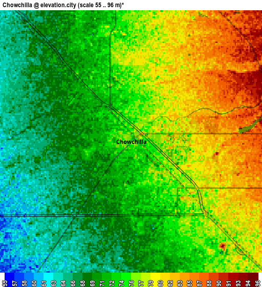
These maps also provides idea of topography and contour of this city, they are displayed at different zoom levels. More info about maps, scale and edge coordinates you can find below images.
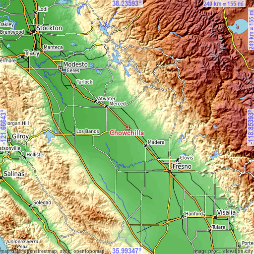
| \ | Map #1 | Map #2 | Topo.Map |
| Scale [m] | 64..86 m | 55..96 m | × |
| Scale [ft] | 210..282 ft | 180..315 ft | × |
| Average | 74.1 m = 243 ft | 73.8 m = 242 ft | × |
| Width | 7.79 km = 4.8 mi | 15.58 km = 9.7 mi | 249.3 km = 154.9 mi |
| Height | 7.79 km = 4.8 mi | 15.58 km = 9.7 mi | 249.3 km = 154.9 mi |
| ↑Max Latitude | 37.158031° | 37.193046° | 38.23593° |
| Latitude at center | 37.123° | 37.123° | 37.123° |
| ↓Min Latitude | 37.087952° | 37.052889° | 35.99347° |
| ← Min Longitude | -120.304125° | -120.348071° | -121.66643° |
| Longitude center | -120.26018° | -120.26018° | -120.26018° |
| →Max Longitude | -120.216235° | -120.172289° | -118.85393° |
Nearby cities:
Cities around Chowchilla sort by population:
• Merced elevation 56 m
28 km,  315°
315°
• Madera 87 m
25.2 km,  135°
135°
• Madera Acres 88 m
20.7 km,  123°
123°
• Bonadelle Ranchos-Madera Ranchos 116 m
37.5 km,  114°
114°
• Firebaugh 46 m
34.1 km,  210°
210°
• Dos Palos 38 m
35.9 km,  244°
244°
• Planada 72 m
19.4 km,  344°
344°
• Parksdale 86 m
28.7 km,  132°
132°
• Parkwood 83 m
29 km, 138°
• Le Grand 81 m
11.8 km,  5°
5°
• South Dos Palos 33 m
39.1 km, 243°
• Fairmead 77 m
7.9 km, 131°
Multilingual:
 En español:
Chowchilla elevación 75 m.
 En France:
Chowchilla élévation 75 m.
 Auf Deutsch:
Chowchilla höhe über dem Meeresspiegel ist 75 m.

Sources and notes:
- [note 1] Map square and city borders are not equal. Map elevation data is calculated only from area inside that square.
- [src 1] Elevation data from geonames database provided with same terms of usage.
- [src 2] The elevation map of Chowchilla is generated using elevation data from NASA's 3 arcsec (90m) resolution SRTM data.
- [src 3] Base (background) map © OpenStreetMap contributors tiles are generated by Geofabrik and OpenTopoMap.
Copyright & License:
This Chowchilla Elevation Map is licensed under CC BY-SA. You may reuse any part from this page, if you give a proper credit by linking to this URL:
 More info on terms of use page.