Rock Port elevation
Rock Port (Missouri, Atchison County), United States elevation is 287 meters and Rock Port elevation in feet is 942 ft above sea level [src 1]. Rock Port is a seat of a second-order administrative division (feature code) with elevation that is 8 meters (26 ft) bigger than average city elevation in United States.
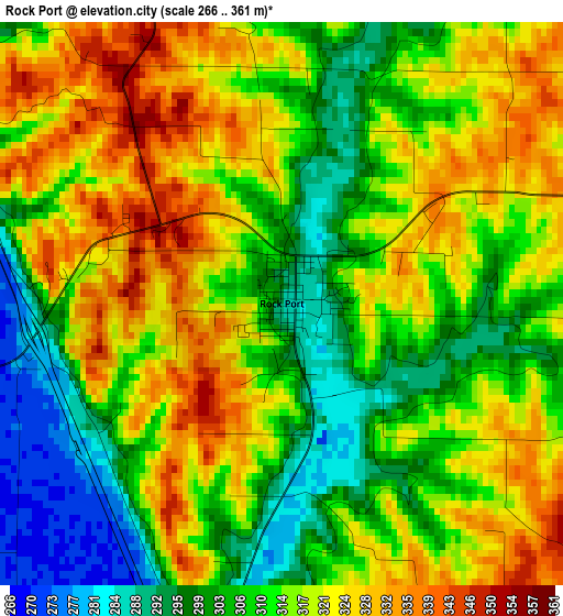
Below is the Elevation map of Rock Port, which displays elevation range with different colors. Scale of the first map is from 266 to 361 m (873 to 1184 ft) with average elevation of 313.9 meters (=1030 ft) [note 1]
These maps also provides idea of topography and contour of this city, they are displayed at different zoom levels. More info about maps, scale and edge coordinates you can find below images.
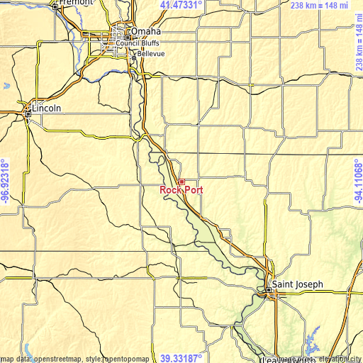
| \ | Map #1 | Topo.Map |
| Scale [m] | 266..361 m | × |
| Scale [ft] | 873..1184 ft | × |
| Average | 313.9 m = 1030 ft | × |
| Width | 7.44 km = 4.6 mi | 238.1 km = 147.9 mi |
| Height | 7.44 km = 4.6 mi | 238.1 km = 147.9 mi |
| ↑Max Latitude | 40.444562° | 41.47331° |
| Latitude at center | 40.41111° | 40.41111° |
| ↓Min Latitude | 40.377641° | 39.33187° |
| ← Min Longitude | -95.560875° | -96.92318° |
| Longitude center | -95.51693° | -95.51693° |
| →Max Longitude | -95.472985° | -94.11068° |
Nearby cities:
Cities around Rock Port sort by population:
• Maryville elevation 355 m
55.1 km,  97°
97°
• Nebraska City 322 m
41.3 km,  315°
315°
• Clarinda 317 m
54.5 km,  47°
47°
• Shenandoah 297 m
41.3 km,  17°
17°
• Falls City 309 m
39.6 km,  190°
190°
• Auburn 302 m
27.3 km,  265°
265°
• Tecumseh 346 m
57.7 km, 265°
• Tarkio 281 m
12.2 km,  74°
74°
• Hamburg 282 m
24.6 km,  331°
331°
• Mound City 273 m
39.4 km,  142°
142°
• Sidney 357 m
39.1 km,  343°
343°
• Oregon 337 m
56.8 km,  146°
146°
Multilingual:
 En español:
Rock Port elevación 287 m.
 En France:
Rock Port élévation 287 m.
 Auf Deutsch:
Rock Port höhe über dem Meeresspiegel ist 287 m.

Sources and notes:
- [note 1] Map square and city borders are not equal. Map elevation data is calculated only from area inside that square.
- [src 1] Elevation data from geonames database provided with same terms of usage.
- [src 2] The elevation map of Rock Port is generated using elevation data from NASA's 3 arcsec (90m) resolution SRTM data.
- [src 3] Base (background) map © OpenStreetMap contributors tiles are generated by Geofabrik and OpenTopoMap.
Copyright & License:
This Rock Port Elevation Map is licensed under CC BY-SA. You may reuse any part from this page, if you give a proper credit by linking to this URL:
 More info on terms of use page.