Maryville elevation
Maryville (Missouri, Nodaway County), United States elevation is 355 meters and Maryville elevation in feet is 1165 ft above sea level [src 1]. Maryville is a seat of a second-order administrative division (feature code) with elevation that is 76 meters (249 ft) bigger than average city elevation in United States.
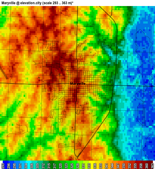
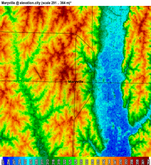
Below is the Elevation map of Maryville, which displays elevation range with different colors. Scale of the first map is from 293 to 363 m (961 to 1191 ft) with average elevation of 329.7 meters (=1082 ft) [note 1]
These maps also provides idea of topography and contour of this city, they are displayed at different zoom levels. More info about maps, scale and edge coordinates you can find below images.

| \ | Map #1 | Map #2 | Topo.Map |
| Scale [m] | 293..363 m | 291..364 m | × |
| Scale [ft] | 961..1191 ft | 955..1194 ft | × |
| Average | 329.7 m = 1082 ft | 329.6 m = 1081 ft | × |
| Width | 7.45 km = 4.6 mi | 14.9 km = 9.3 mi | 238.3 km = 148.1 mi |
| Height | 7.45 km = 4.6 mi | 14.9 km = 9.3 mi | 238.3 km = 148.1 mi |
| ↑Max Latitude | 40.379585° | 40.413052° | 41.40934° |
| Latitude at center | 40.3461° | 40.3461° | 40.3461° |
| ↓Min Latitude | 40.312599° | 40.279081° | 39.26583° |
| ← Min Longitude | -94.916415° | -94.960361° | -96.27872° |
| Longitude center | -94.87247° | -94.87247° | -94.87247° |
| →Max Longitude | -94.828525° | -94.784579° | -93.46622° |
Nearby cities:
Cities around Maryville sort by population:
• Clarinda elevation 317 m
46 km,  342°
342°
• Savannah 339 m
45.1 km,  175°
175°
• Country Club Village 329 m
57.3 km, 175°
• Albany 282 m
47.2 km,  103°
103°
• Tarkio 281 m
44.1 km,  283°
283°
• Bedford 345 m
37.9 km,  19°
19°
• Rock Port 287 m
55.1 km, 277°
• Stanberry 295 m
31.7 km,  116°
116°
• Mound City 273 m
38.7 km,  231°
231°
• King City 342 m
44.1 km,  137°
137°
• Grant City 342 m
42.1 km,  68°
68°
• Oregon 337 m
46.2 km,  210°
210°
Multilingual:
 En español:
Maryville elevación 355 m.
 En France:
Maryville élévation 355 m.
 Auf Deutsch:
Maryville höhe über dem Meeresspiegel ist 355 m.

Sources and notes:
- [note 1] Map square and city borders are not equal. Map elevation data is calculated only from area inside that square.
- [src 1] Elevation data from geonames database provided with same terms of usage.
- [src 2] The elevation map of Maryville is generated using elevation data from NASA's 3 arcsec (90m) resolution SRTM data.
- [src 3] Base (background) map © OpenStreetMap contributors tiles are generated by Geofabrik and OpenTopoMap.
Copyright & License:
This Maryville Elevation Map is licensed under CC BY-SA. You may reuse any part from this page, if you give a proper credit by linking to this URL:
 More info on terms of use page.