Grant City elevation
Grant City (Missouri, Worth County), United States elevation is 342 meters and Grant City elevation in feet is 1122 ft above sea level [src 1]. Grant City is a seat of a second-order administrative division (feature code) with elevation that is 63 meters (207 ft) bigger than average city elevation in United States.
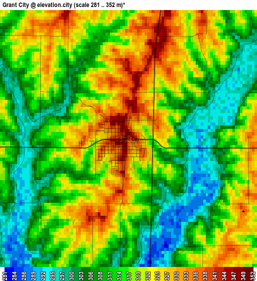
Below is the Elevation map of Grant City, which displays elevation range with different colors. Scale of the first map is from 281 to 352 m (922 to 1155 ft) with average elevation of 315.2 meters (=1034 ft) [note 1]
These maps also provides idea of topography and contour of this city, they are displayed at different zoom levels. More info about maps, scale and edge coordinates you can find below images.
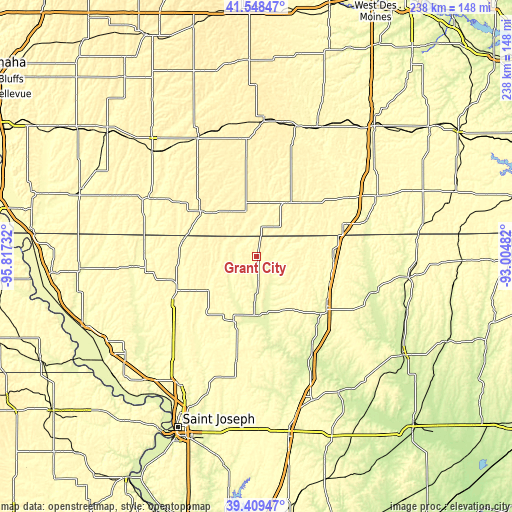
| \ | Map #1 | Topo.Map |
| Scale [m] | 281..352 m | × |
| Scale [ft] | 922..1155 ft | × |
| Average | 315.2 m = 1034 ft | × |
| Width | 7.43 km = 4.6 mi | 237.8 km = 147.8 mi |
| Height | 7.43 km = 4.6 mi | 237.8 km = 147.8 mi |
| ↑Max Latitude | 40.520904° | 41.54847° |
| Latitude at center | 40.48749° | 40.48749° |
| ↓Min Latitude | 40.454059° | 39.40947° |
| ← Min Longitude | -94.455015° | -95.81732° |
| Longitude center | -94.41107° | -94.41107° |
| →Max Longitude | -94.367125° | -93.00482° |
Nearby cities:
Cities around Grant City sort by population:
• Maryville elevation 355 m
42.1 km,  248°
248°
• Clarinda 317 m
59.9 km,  297°
297°
• Bethany 278 m
40.6 km,  126°
126°
• Lamoni 346 m
43 km,  69°
69°
• Leon 344 m
62.6 km,  63°
63°
• Albany 282 m
27.4 km,  165°
165°
• Mount Ayr 376 m
29.3 km,  30°
30°
• Corning 365 m
62.4 km,  333°
333°
• Bedford 345 m
32.9 km,  307°
307°
• Lenox 397 m
45.6 km,  343°
343°
• Stanberry 295 m
31.9 km,  199°
199°
• King City 342 m
49.4 km,  191°
191°
Multilingual:
 En español:
Grant City elevación 342 m.
 En France:
Grant City élévation 342 m.
 Auf Deutsch:
Grant City höhe über dem Meeresspiegel ist 342 m.

Sources and notes:
- [note 1] Map square and city borders are not equal. Map elevation data is calculated only from area inside that square.
- [src 1] Elevation data from geonames database provided with same terms of usage.
- [src 2] The elevation map of Grant City is generated using elevation data from NASA's 3 arcsec (90m) resolution SRTM data.
- [src 3] Base (background) map © OpenStreetMap contributors tiles are generated by Geofabrik and OpenTopoMap.
Copyright & License:
This Grant City Elevation Map is licensed under CC BY-SA. You may reuse any part from this page, if you give a proper credit by linking to this URL:
 More info on terms of use page.