Corning elevation
Corning (Iowa, Adams County), United States elevation is 365 meters and Corning elevation in feet is 1198 ft above sea level [src 1]. Corning is a seat of a second-order administrative division (feature code) with elevation that is 86 meters (282 ft) bigger than average city elevation in United States.
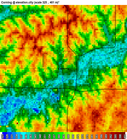
Below is the Elevation map of Corning, which displays elevation range with different colors. Scale of the first map is from 325 to 401 m (1066 to 1316 ft) with average elevation of 364.5 meters (=1196 ft) [note 1]
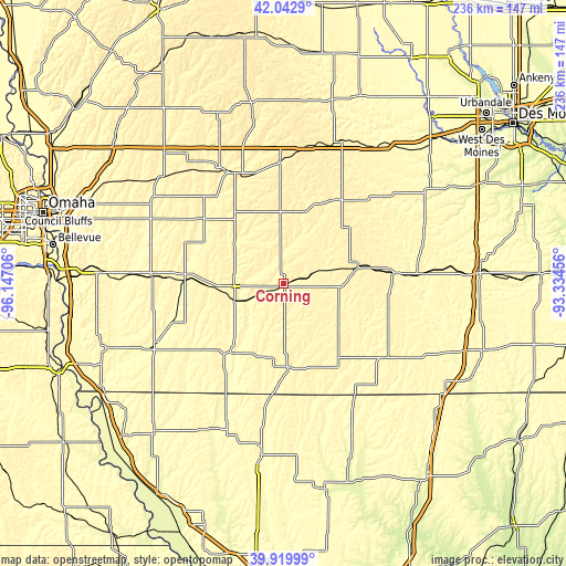
These maps also provides idea of topography and contour of this city, they are displayed at different zoom levels. More info about maps, scale and edge coordinates you can find below images.
| \ | Map #1 | Topo.Map |
| Scale [m] | 325..401 m | × |
| Scale [ft] | 1066..1316 ft | × |
| Average | 364.5 m = 1196 ft | × |
| Width | 7.38 km = 4.6 mi | 236 km = 146.6 mi |
| Height | 7.38 km = 4.6 mi | 236 km = 146.6 mi |
| ↑Max Latitude | 41.023153° | 42.0429° |
| Latitude at center | 40.98999° | 40.98999° |
| ↓Min Latitude | 40.956811° | 39.91999° |
| ← Min Longitude | -94.784755° | -96.14706° |
| Longitude center | -94.74081° | -94.74081° |
| →Max Longitude | -94.696865° | -93.33456° |
Nearby cities:
Cities around Corning sort by population:
• Creston elevation 401 m
32.7 km,  76°
76°
• Atlantic 372 m
51.4 km,  333°
333°
• Red Oak 320 m
40.7 km,  273°
273°
• Clarinda 317 m
37.4 km,  221°
221°
• Shenandoah 297 m
58.7 km,  244°
244°
• Greenfield 417 m
42.1 km,  33°
33°
• Mount Ayr 376 m
52.4 km,  125°
125°
• Oakland 342 m
65.4 km,  302°
302°
• Bedford 345 m
36 km,  177°
177°
• Lenox 397 m
19.3 km, 128°
• Villisca 327 m
20.9 km,  251°
251°
• Grant City 342 m
62.4 km,  153°
153°
Multilingual:
 En español:
Corning elevación 365 m.
 En France:
Corning élévation 365 m.


Sources and notes:
- [note 1] Map square and city borders are not equal. Map elevation data is calculated only from area inside that square.
- [src 1] Elevation data from geonames database provided with same terms of usage.
- [src 2] The elevation map of Corning is generated using elevation data from NASA's 3 arcsec (90m) resolution SRTM data.
- [src 3] Base (background) map © OpenStreetMap contributors tiles are generated by Geofabrik and OpenTopoMap.
Copyright & License:
This Corning Elevation Map is licensed under CC BY-SA. You may reuse any part from this page, if you give a proper credit by linking to this URL:
 More info on terms of use page.