Clarinda elevation
Clarinda (Iowa, Page County), United States elevation is 317 meters and Clarinda elevation in feet is 1040 ft above sea level [src 1]. Clarinda is a seat of a second-order administrative division (feature code) with elevation that is 38 meters (125 ft) bigger than average city elevation in United States.
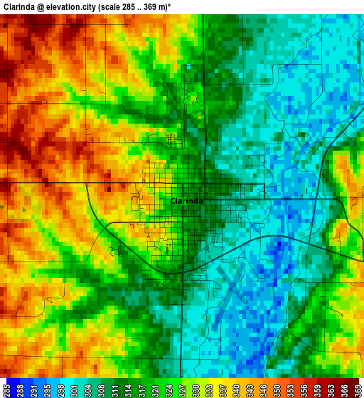
Below is the Elevation map of Clarinda, which displays elevation range with different colors. Scale of the first map is from 285 to 369 m (935 to 1211 ft) with average elevation of 322 meters (=1056 ft) [note 1]
These maps also provides idea of topography and contour of this city, they are displayed at different zoom levels. More info about maps, scale and edge coordinates you can find below images.
| \ | Map #1 | Map #2 | Topo.Map |
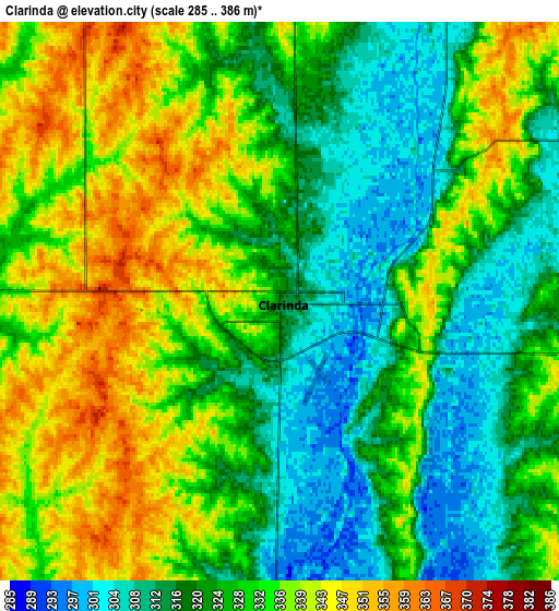
| Scale [m] | 285..369 m | 285..386 m | × |
| Scale [ft] | 935..1211 ft | 935..1266 ft | × |
| Average | 322 m = 1056 ft | 328 m = 1076 ft | × |
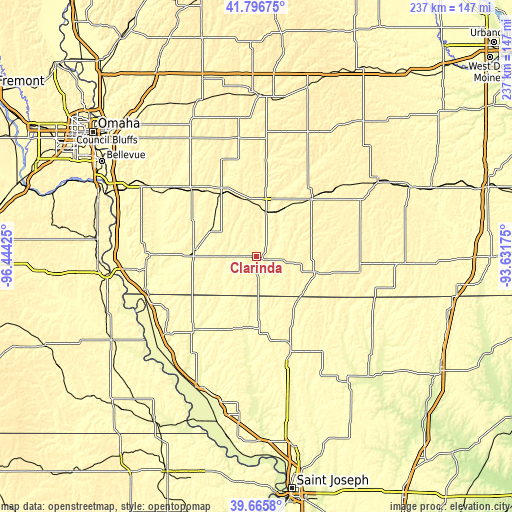
| Width | 7.4 km = 4.6 mi | 14.81 km = 9.2 mi | 236.9 km = 147.2 mi |
| Height | 7.4 km = 4.6 mi | 14.81 km = 9.2 mi | 236.9 km = 147.2 mi |
| ↑Max Latitude | 40.773098° | 40.80637° | 41.79675° |
| Latitude at center | 40.73981° | 40.73981° | 40.73981° |
| ↓Min Latitude | 40.706505° | 40.673184° | 39.6658° |
| ← Min Longitude | -95.081945° | -95.125891° | -96.44425° |
| Longitude center | -95.038° | -95.038° | -95.038° |
| →Max Longitude | -94.994055° | -94.950109° | -93.63175° |
Nearby cities:
Cities around Clarinda sort by population:
• Maryville elevation 355 m
46 km,  162°
162°
• Red Oak 320 m
33.9 km,  332°
332°
• Shenandoah 297 m
28.3 km,  275°
275°
• Corning 365 m
37.4 km,  41°
41°
• Tarkio 281 m
44 km,  220°
220°
• Bedford 345 m
27.9 km,  106°
106°
• Lenox 397 m
43.1 km,  68°
68°
• Rock Port 287 m
54.5 km,  227°
227°
• Villisca 327 m
21.7 km,  13°
13°
• Malvern 306 m
54.5 km,  302°
302°
• Hamburg 282 m
54.4 km,  253°
253°
• Sidney 357 m
51.4 km,  271°
271°
Multilingual:
 En español:
Clarinda elevación 317 m.
 En France:
Clarinda élévation 317 m.
 Auf Deutsch:
Clarinda höhe über dem Meeresspiegel ist 317 m.

Sources and notes:
- [note 1] Map square and city borders are not equal. Map elevation data is calculated only from area inside that square.
- [src 1] Elevation data from geonames database provided with same terms of usage.
- [src 2] The elevation map of Clarinda is generated using elevation data from NASA's 3 arcsec (90m) resolution SRTM data.
- [src 3] Base (background) map © OpenStreetMap contributors tiles are generated by Geofabrik and OpenTopoMap.
Copyright & License:
This Clarinda Elevation Map is licensed under CC BY-SA. You may reuse any part from this page, if you give a proper credit by linking to this URL:
 More info on terms of use page.