Sidney elevation
Sidney (Iowa, Fremont County), United States elevation is 357 meters and Sidney elevation in feet is 1171 ft above sea level [src 1]. Sidney is a seat of a second-order administrative division (feature code) with elevation that is 78 meters (256 ft) bigger than average city elevation in United States.
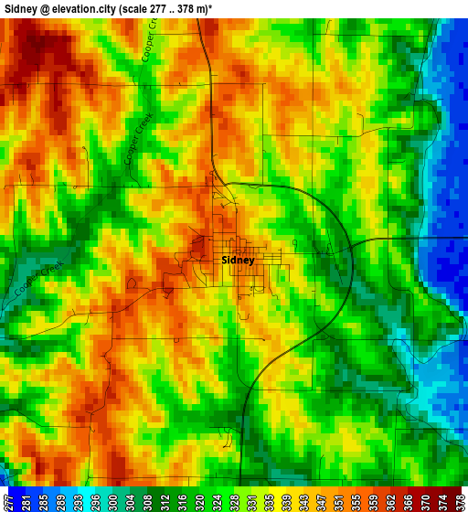
Below is the Elevation map of Sidney, which displays elevation range with different colors. Scale of the first map is from 277 to 378 m (909 to 1240 ft) with average elevation of 330.2 meters (=1083 ft) [note 1]
These maps also provides idea of topography and contour of this city, they are displayed at different zoom levels. More info about maps, scale and edge coordinates you can find below images.
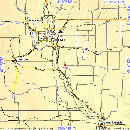
| \ | Map #1 | Topo.Map |
| Scale [m] | 277..378 m | × |
| Scale [ft] | 909..1240 ft | × |
| Average | 330.2 m = 1083 ft | × |
| Width | 7.4 km = 4.6 mi | 236.9 km = 147.2 mi |
| Height | 7.4 km = 4.6 mi | 236.9 km = 147.2 mi |
| ↑Max Latitude | 40.781614° | 41.80513° |
| Latitude at center | 40.74833° | 40.74833° |
| ↓Min Latitude | 40.715029° | 39.67446° |
| ← Min Longitude | -95.691445° | -97.05375° |
| Longitude center | -95.6475° | -95.6475° |
| →Max Longitude | -95.603555° | -94.24125° |
Nearby cities:
Cities around Sidney sort by population:
• Nebraska City elevation 322 m
19.5 km,  245°
245°
• Plattsmouth 304 m
35.3 km,  325°
325°
• Red Oak 320 m
45.9 km,  50°
50°
• Glenwood 308 m
34.1 km,  346°
346°
• Shenandoah 297 m
23.3 km,  85°
85°
• Auburn 302 m
42.7 km,  202°
202°
• Syracuse 320 m
46.5 km,  257°
257°
• Tarkio 281 m
41.1 km,  146°
146°
• Rock Port 287 m
39.1 km,  163°
163°
• Malvern 306 m
28.8 km,  10°
10°
• Hamburg 282 m
16 km,  183°
183°
• Weeping Water 337 m
43.6 km,  288°
288°
Multilingual:
 En español:
Sidney elevación 357 m.
 En France:
Sidney élévation 357 m.


Sources and notes:
- [note 1] Map square and city borders are not equal. Map elevation data is calculated only from area inside that square.
- [src 1] Elevation data from geonames database provided with same terms of usage.
- [src 2] The elevation map of Sidney is generated using elevation data from NASA's 3 arcsec (90m) resolution SRTM data.
- [src 3] Base (background) map © OpenStreetMap contributors tiles are generated by Geofabrik and OpenTopoMap.
Copyright & License:
This Sidney Elevation Map is licensed under CC BY-SA. You may reuse any part from this page, if you give a proper credit by linking to this URL:
 More info on terms of use page.