Lamoni elevation
Lamoni (Iowa, Decatur County), United States elevation is 346 meters and Lamoni elevation in feet is 1135 ft above sea level [src 1]. Lamoni is a populated place (feature code) with elevation that is 67 meters (220 ft) bigger than average city elevation in United States.
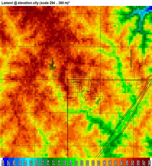
Below is the Elevation map of Lamoni, which displays elevation range with different colors. Scale of the first map is from 294 to 360 m (965 to 1181 ft) with average elevation of 340.2 meters (=1116 ft) [note 1]
These maps also provides idea of topography and contour of this city, they are displayed at different zoom levels. More info about maps, scale and edge coordinates you can find below images.
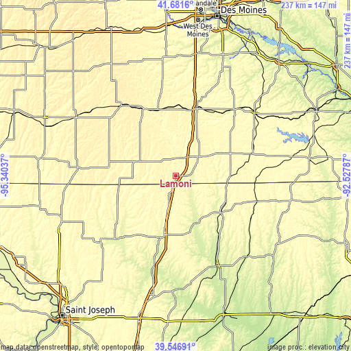
| \ | Map #1 | Topo.Map |
| Scale [m] | 294..360 m | × |
| Scale [ft] | 965..1181 ft | × |
| Average | 340.2 m = 1116 ft | × |
| Width | 7.42 km = 4.6 mi | 237.4 km = 147.5 mi |
| Height | 7.42 km = 4.6 mi | 237.3 km = 147.5 mi |
| ↑Max Latitude | 40.656127° | 41.6816° |
| Latitude at center | 40.62278° | 40.62278° |
| ↓Min Latitude | 40.589417° | 39.54691° |
| ← Min Longitude | -93.978065° | -95.34037° |
| Longitude center | -93.93412° | -93.93412° |
| →Max Longitude | -93.890175° | -92.52787° |
Nearby cities:
Cities around Lamoni sort by population:
• Creston elevation 401 m
60.3 km,  323°
323°
• Trenton 261 m
66.2 km,  156°
156°
• Osceola 350 m
47.9 km,  17°
17°
• Bethany 278 m
40.2 km,  191°
191°
• Terre Haute 318 m
62.6 km,  109°
109°
• Leon 344 m
20.4 km,  50°
50°
• Albany 282 m
53.5 km,  218°
218°
• Mount Ayr 376 m
27.4 km,  291°
291°
• Corydon 334 m
54 km,  73°
73°
• Lenox 397 m
60.2 km,  298°
298°
• Princeton 296 m
38.8 km,  129°
129°
• Grant City 342 m
43 km,  249°
249°
Multilingual:
 En español:
Lamoni elevación 346 m.
 En France:
Lamoni élévation 346 m.


Sources and notes:
- [note 1] Map square and city borders are not equal. Map elevation data is calculated only from area inside that square.
- [src 1] Elevation data from geonames database provided with same terms of usage.
- [src 2] The elevation map of Lamoni is generated using elevation data from NASA's 3 arcsec (90m) resolution SRTM data.
- [src 3] Base (background) map © OpenStreetMap contributors tiles are generated by Geofabrik and OpenTopoMap.
Copyright & License:
This Lamoni Elevation Map is licensed under CC BY-SA. You may reuse any part from this page, if you give a proper credit by linking to this URL:
 More info on terms of use page.