Trenton elevation
Trenton (Missouri, Grundy County), United States elevation is 261 meters and Trenton elevation in feet is 856 ft above sea level [src 1]. Trenton is a seat of a second-order administrative division (feature code) with elevation that is 18 meters (59 ft) smaller than average city elevation in United States.
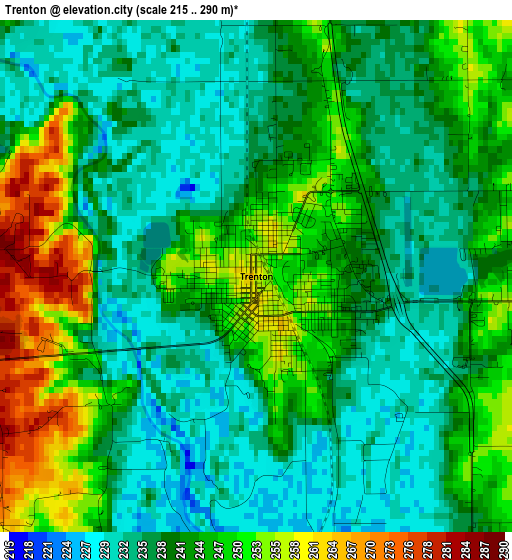
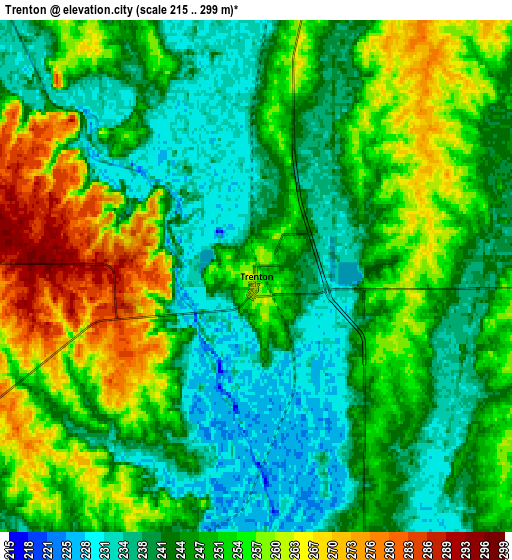
Below is the Elevation map of Trenton, which displays elevation range with different colors. Scale of the first map is from 215 to 290 m (705 to 951 ft) with average elevation of 241.6 meters (=793 ft) [note 1]
These maps also provides idea of topography and contour of this city, they are displayed at different zoom levels. More info about maps, scale and edge coordinates you can find below images.
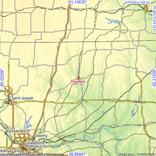
| \ | Map #1 | Map #2 | Topo.Map |
| Scale [m] | 215..290 m | 215..299 m | × |
| Scale [ft] | 705..951 ft | 705..981 ft | × |
| Average | 241.6 m = 793 ft | 248.5 m = 815 ft | × |
| Width | 7.48 km = 4.6 mi | 14.96 km = 9.3 mi | 239.3 km = 148.7 mi |
| Height | 7.48 km = 4.6 mi | 14.95 km = 9.3 mi | 239.3 km = 148.7 mi |
| ↑Max Latitude | 40.112517° | 40.146117° | 41.14639° |
| Latitude at center | 40.0789° | 40.0789° | 40.0789° |
| ↓Min Latitude | 40.045267° | 40.011617° | 38.99441° |
| ← Min Longitude | -93.660555° | -93.704501° | -95.02286° |
| Longitude center | -93.61661° | -93.61661° | -93.61661° |
| →Max Longitude | -93.572665° | -93.528719° | -92.21036° |
Nearby cities:
Cities around Trenton sort by population:
• Cameron elevation 317 m
65.2 km,  234°
234°
• Chillicothe 244 m
32 km,  170°
170°
• Brookfield 232 m
56.7 km,  125°
125°
• Bethany 278 m
40.8 km,  301°
301°
• Terre Haute 318 m
51.6 km,  38°
38°
• Milan 298 m
44 km,  71°
71°
• Gallatin 285 m
34.7 km,  238°
238°
• Hamilton 306 m
49.5 km,  221°
221°
• Albany 282 m
63.6 km,  287°
287°
• Princeton 296 m
35.9 km,  4°
4°
• Kingston 276 m
60.3 km, 216°
• Linneus 257 m
42.7 km,  121°
121°
Multilingual:
 En español:
Trenton elevación 261 m.
 En France:
Trenton élévation 261 m.


Sources and notes:
- [note 1] Map square and city borders are not equal. Map elevation data is calculated only from area inside that square.
- [src 1] Elevation data from geonames database provided with same terms of usage.
- [src 2] The elevation map of Trenton is generated using elevation data from NASA's 3 arcsec (90m) resolution SRTM data.
- [src 3] Base (background) map © OpenStreetMap contributors tiles are generated by Geofabrik and OpenTopoMap.
Copyright & License:
This Trenton Elevation Map is licensed under CC BY-SA. You may reuse any part from this page, if you give a proper credit by linking to this URL:
 More info on terms of use page.