Hamilton elevation
Hamilton (Missouri, Caldwell County), United States elevation is 306 meters and Hamilton elevation in feet is 1004 ft above sea level [src 1]. Hamilton is a populated place (feature code) with elevation that is 27 meters (89 ft) bigger than average city elevation in United States.
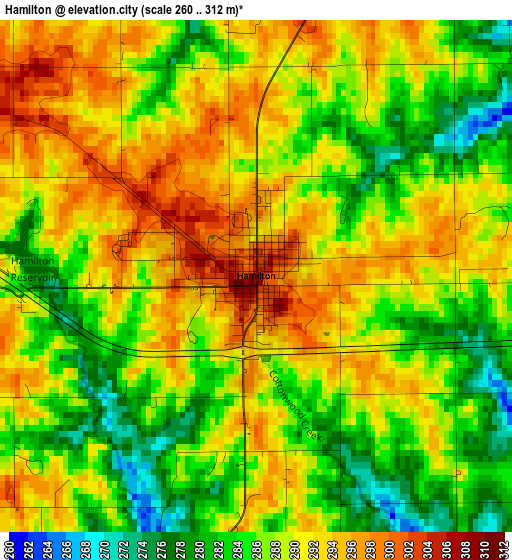
Below is the Elevation map of Hamilton, which displays elevation range with different colors. Scale of the first map is from 260 to 312 m (853 to 1024 ft) with average elevation of 288.3 meters (=946 ft) [note 1]
These maps also provides idea of topography and contour of this city, they are displayed at different zoom levels. More info about maps, scale and edge coordinates you can find below images.
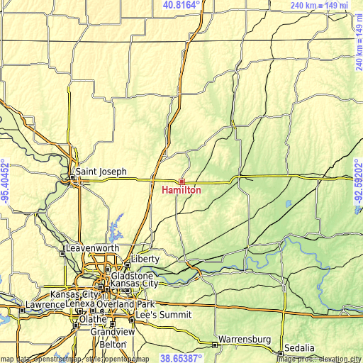
| \ | Map #1 | Topo.Map |
| Scale [m] | 260..312 m | × |
| Scale [ft] | 853..1024 ft | × |
| Average | 288.3 m = 946 ft | × |
| Width | 7.51 km = 4.7 mi | 240.5 km = 149.4 mi |
| Height | 7.51 km = 4.7 mi | 240.4 km = 149.4 mi |
| ↑Max Latitude | 39.777402° | 40.8164° |
| Latitude at center | 39.74362° | 39.74362° |
| ↓Min Latitude | 39.709822° | 38.65387° |
| ← Min Longitude | -94.042215° | -95.40452° |
| Longitude center | -93.99827° | -93.99827° |
| →Max Longitude | -93.954325° | -92.59202° |
Nearby cities:
Cities around Hamilton sort by population:
• Excelsior Springs elevation 242 m
49 km,  203°
203°
• Cameron 317 m
20.8 km,  268°
268°
• Chillicothe 244 m
38.5 km,  81°
81°
• Kearney 264 m
52.1 km,  216°
216°
• Trenton 261 m
49.5 km,  41°
41°
• Richmond 253 m
51.7 km,  177°
177°
• Lawson 328 m
38.3 km,  207°
207°
• Plattsburg 290 m
43.3 km,  242°
242°
• Lathrop 327 m
35.7 km,  232°
232°
• Gallatin 285 m
19.2 km,  9°
9°
• Maysville 297 m
35 km,  297°
297°
• Kingston 276 m
11.6 km, 197°
Multilingual:
 En español:
Hamilton elevación 306 m.
 En France:
Hamilton élévation 306 m.
 Auf Deutsch:
Hamilton höhe über dem Meeresspiegel ist 306 m.

Sources and notes:
- [note 1] Map square and city borders are not equal. Map elevation data is calculated only from area inside that square.
- [src 1] Elevation data from geonames database provided with same terms of usage.
- [src 2] The elevation map of Hamilton is generated using elevation data from NASA's 3 arcsec (90m) resolution SRTM data.
- [src 3] Base (background) map © OpenStreetMap contributors tiles are generated by Geofabrik and OpenTopoMap.
Copyright & License:
This Hamilton Elevation Map is licensed under CC BY-SA. You may reuse any part from this page, if you give a proper credit by linking to this URL:
 More info on terms of use page.