Maysville elevation
Maysville (Missouri, DeKalb County), United States elevation is 297 meters and Maysville elevation in feet is 974 ft above sea level [src 1]. Maysville is a seat of a second-order administrative division (feature code) with elevation that is 18 meters (59 ft) bigger than average city elevation in United States.
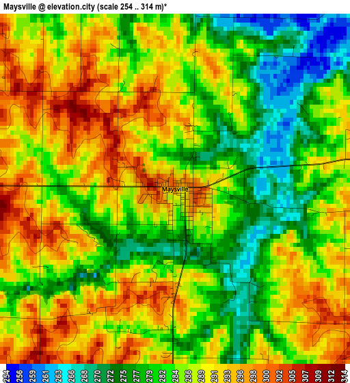
Below is the Elevation map of Maysville, which displays elevation range with different colors. Scale of the first map is from 254 to 314 m (833 to 1030 ft) with average elevation of 285.9 meters (=938 ft) [note 1]
These maps also provides idea of topography and contour of this city, they are displayed at different zoom levels. More info about maps, scale and edge coordinates you can find below images.
| \ | Map #1 | Topo.Map |
| Scale [m] | 254..314 m | × |
| Scale [ft] | 833..1030 ft | × |
| Average | 285.9 m = 938 ft | × |
| Width | 7.5 km = 4.7 mi | 239.9 km = 149.1 mi |
| Height | 7.5 km = 4.7 mi | 239.9 km = 149.1 mi |
| ↑Max Latitude | 39.92288° | 40.95966° |
| Latitude at center | 39.88917° | 39.88917° |
| ↓Min Latitude | 39.855443° | 38.8017° |
| ← Min Longitude | -94.405845° | -95.76815° |
| Longitude center | -94.3619° | -94.3619° |
| →Max Longitude | -94.317955° | -92.95565° |
Nearby cities:
Cities around Maysville sort by population:
• Cameron elevation 317 m
19.5 km,  148°
148°
• Savannah 339 m
40.4 km,  278°
278°
• Country Club Village 329 m
39.7 km,  260°
260°
• Plattsburg 290 m
36.7 km,  191°
191°
• Lathrop 327 m
38 km,  175°
175°
• Gallatin 285 m
34.2 km,  85°
85°
• Hamilton 306 m
35 km,  117°
117°
• Albany 282 m
40.1 km,  3°
3°
• Gower 292 m
37 km,  213°
213°
• Stanberry 295 m
39.5 km,  337°
337°
• King City 342 m
22.7 km,  322°
322°
• Kingston 276 m
38.8 km,  134°
134°
Multilingual:
 En español:
Maysville elevación 297 m.
 En France:
Maysville élévation 297 m.
 Auf Deutsch:
Maysville höhe über dem Meeresspiegel ist 297 m.

Sources and notes:
- [note 1] Map square and city borders are not equal. Map elevation data is calculated only from area inside that square.
- [src 1] Elevation data from geonames database provided with same terms of usage.
- [src 2] The elevation map of Maysville is generated using elevation data from NASA's 3 arcsec (90m) resolution SRTM data.
- [src 3] Base (background) map © OpenStreetMap contributors tiles are generated by Geofabrik and OpenTopoMap.
Copyright & License:
This Maysville Elevation Map is licensed under CC BY-SA. You may reuse any part from this page, if you give a proper credit by linking to this URL:
 More info on terms of use page.