Gower elevation
Gower (Missouri, Clinton County), United States elevation is 292 meters and Gower elevation in feet is 958 ft above sea level [src 1]. Gower is a populated place (feature code) with elevation that is 13 meters (43 ft) bigger than average city elevation in United States.
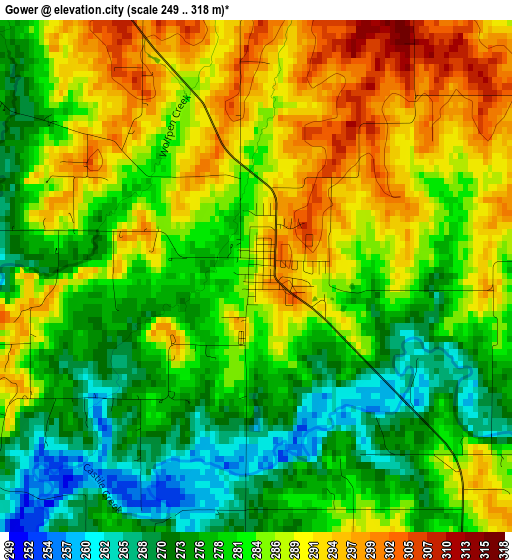
Below is the Elevation map of Gower, which displays elevation range with different colors. Scale of the first map is from 249 to 318 m (817 to 1043 ft) with average elevation of 283 meters (=928 ft) [note 1]
These maps also provides idea of topography and contour of this city, they are displayed at different zoom levels. More info about maps, scale and edge coordinates you can find below images.
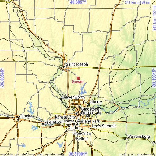
| \ | Map #1 | Topo.Map |
| Scale [m] | 249..318 m | × |
| Scale [ft] | 817..1043 ft | × |
| Average | 283 m = 928 ft | × |
| Width | 7.53 km = 4.7 mi | 240.9 km = 149.7 mi |
| Height | 7.53 km = 4.7 mi | 240.9 km = 149.7 mi |
| ↑Max Latitude | 39.644677° | 40.6857° |
| Latitude at center | 39.61083° | 39.61083° |
| ↓Min Latitude | 39.576967° | 38.51901° |
| ← Min Longitude | -94.643345° | -96.00565° |
| Longitude center | -94.5994° | -94.5994° |
| →Max Longitude | -94.555455° | -93.19315° |
Nearby cities:
Cities around Gower sort by population:
• Saint Joseph elevation 279 m
27.5 km,  309°
309°
• Cameron 317 m
33.9 km,  64°
64°
• Kearney 264 m
33.8 km,  143°
143°
• Smithville 251 m
24.9 km,  176°
176°
• Platte City 250 m
31 km,  210°
210°
• Country Club Village 329 m
31.1 km,  322°
322°
• Plattsburg 290 m
13.9 km,  111°
111°
• Lathrop 327 m
24.1 km, 106°
• Weston 247 m
34.1 km,  229°
229°
• Wathena 256 m
34.2 km,  298°
298°
• Elwood 252 m
28.4 km, 304°
• Maysville 297 m
37 km,  33°
33°
Multilingual:
 En español:
Gower elevación 292 m.
 En France:
Gower élévation 292 m.


Sources and notes:
- [note 1] Map square and city borders are not equal. Map elevation data is calculated only from area inside that square.
- [src 1] Elevation data from geonames database provided with same terms of usage.
- [src 2] The elevation map of Gower is generated using elevation data from NASA's 3 arcsec (90m) resolution SRTM data.
- [src 3] Base (background) map © OpenStreetMap contributors tiles are generated by Geofabrik and OpenTopoMap.
Copyright & License:
This Gower Elevation Map is licensed under CC BY-SA. You may reuse any part from this page, if you give a proper credit by linking to this URL:
 More info on terms of use page.