Pierz elevation
Pierz (Minnesota, Morrison County), United States elevation is 356 meters and Pierz elevation in feet is 1168 ft above sea level [src 1]. Pierz is a populated place (feature code) with elevation that is 77 meters (253 ft) bigger than average city elevation in United States.
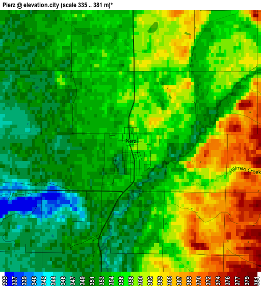
Below is the Elevation map of Pierz, which displays elevation range with different colors. Scale of the first map is from 335 to 381 m (1099 to 1250 ft) with average elevation of 355.6 meters (=1167 ft) [note 1]
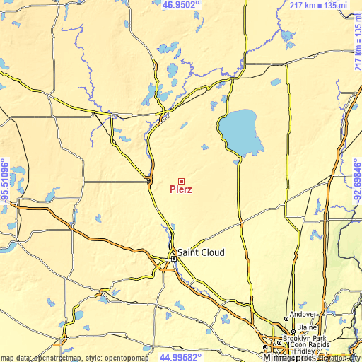
These maps also provides idea of topography and contour of this city, they are displayed at different zoom levels. More info about maps, scale and edge coordinates you can find below images.
| \ | Map #1 | Topo.Map |
| Scale [m] | 335..381 m | × |
| Scale [ft] | 1099..1250 ft | × |
| Average | 355.6 m = 1167 ft | × |
| Width | 6.79 km = 4.2 mi | 217.3 km = 135 mi |
| Height | 6.79 km = 4.2 mi | 217.3 km = 135 mi |
| ↑Max Latitude | 46.012159° | 46.9502° |
| Latitude at center | 45.98163° | 45.98163° |
| ↓Min Latitude | 45.951084° | 44.99582° |
| ← Min Longitude | -94.148655° | -95.51096° |
| Longitude center | -94.10471° | -94.10471° |
| →Max Longitude | -94.060765° | -92.69846° |
Nearby cities:
Cities around Pierz sort by population:
• Saint Cloud elevation 318 m
47 km,  185°
185°
• Sartell 315 m
40.8 km, 191°
• Sauk Rapids 314 m
43.6 km, 186°
• Brainerd 365 m
42.5 km,  349°
349°
• Little Falls 339 m
19.9 km,  268°
268°
• Baxter 366 m
42.6 km,  340°
340°
• Collegeville 333 m
47.5 km,  204°
204°
• Milaca 327 m
43 km,  125°
125°
• Foley 345 m
38.3 km,  156°
156°
• Rice 321 m
27.1 km, 199°
• Royalton 329 m
22.3 km,  220°
220°
• Vineland 381 m
33.6 km,  52°
52°
Multilingual:
 En español:
Pierz elevación 356 m.
 En France:
Pierz élévation 356 m.


Sources and notes:
- [note 1] Map square and city borders are not equal. Map elevation data is calculated only from area inside that square.
- [src 1] Elevation data from geonames database provided with same terms of usage.
- [src 2] The elevation map of Pierz is generated using elevation data from NASA's 3 arcsec (90m) resolution SRTM data.
- [src 3] Base (background) map © OpenStreetMap contributors tiles are generated by Geofabrik and OpenTopoMap.
Copyright & License:
This Pierz Elevation Map is licensed under CC BY-SA. You may reuse any part from this page, if you give a proper credit by linking to this URL:
 More info on terms of use page.