Foley elevation
Foley (Minnesota, Benton County), United States elevation is 345 meters and Foley elevation in feet is 1132 ft above sea level [src 1]. Foley is a seat of a second-order administrative division (feature code) with elevation that is 66 meters (217 ft) bigger than average city elevation in United States.
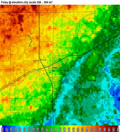
Below is the Elevation map of Foley, which displays elevation range with different colors. Scale of the first map is from 326 to 364 m (1070 to 1194 ft) with average elevation of 344.1 meters (=1129 ft) [note 1]
These maps also provides idea of topography and contour of this city, they are displayed at different zoom levels. More info about maps, scale and edge coordinates you can find below images.
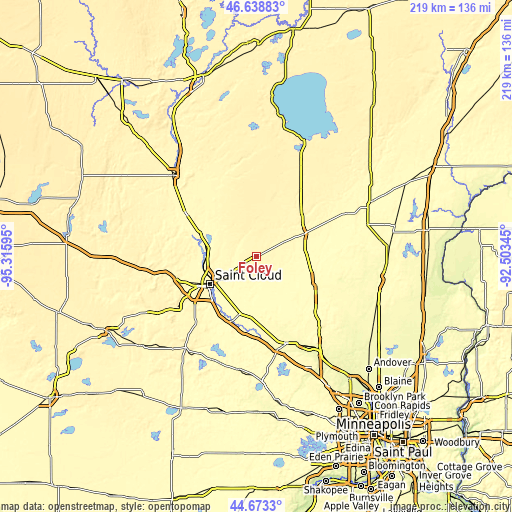
| \ | Map #1 | Topo.Map |
| Scale [m] | 326..364 m | × |
| Scale [ft] | 1070..1194 ft | × |
| Average | 344.1 m = 1129 ft | × |
| Width | 6.83 km = 4.2 mi | 218.5 km = 135.8 mi |
| Height | 6.83 km = 4.2 mi | 218.5 km = 135.8 mi |
| ↑Max Latitude | 45.695393° | 46.63883° |
| Latitude at center | 45.66469° | 45.66469° |
| ↓Min Latitude | 45.63397° | 44.6733° |
| ← Min Longitude | -93.953645° | -95.31595° |
| Longitude center | -93.9097° | -93.9097° |
| →Max Longitude | -93.865755° | -92.50345° |
Nearby cities:
Cities around Foley sort by population:
• Saint Cloud elevation 318 m
22.8 km,  239°
239°
• Sartell 315 m
23.6 km,  258°
258°
• Sauk Rapids 314 m
21.5 km,  247°
247°
• Waite Park 327 m
27.2 km, 243°
• Saint Joseph 334 m
33.7 km, 250°
• Becker 297 m
30.3 km,  175°
175°
• Princeton 299 m
27.6 km,  112°
112°
• Saint Augusta 311 m
32.1 km,  224°
224°
• Saint Augusta 306 m
28.1 km, 222°
• Milaca 327 m
22.3 km,  62°
62°
• Clearwater 295 m
29.3 km,  201°
201°
• Rice 321 m
26 km,  291°
291°
Multilingual:
 En español:
Foley elevación 345 m.
 En France:
Foley élévation 345 m.


Sources and notes:
- [note 1] Map square and city borders are not equal. Map elevation data is calculated only from area inside that square.
- [src 1] Elevation data from geonames database provided with same terms of usage.
- [src 2] The elevation map of Foley is generated using elevation data from NASA's 3 arcsec (90m) resolution SRTM data.
- [src 3] Base (background) map © OpenStreetMap contributors tiles are generated by Geofabrik and OpenTopoMap.
Copyright & License:
This Foley Elevation Map is licensed under CC BY-SA. You may reuse any part from this page, if you give a proper credit by linking to this URL:
 More info on terms of use page.