Milaca elevation
Milaca (Minnesota, Mille Lacs County), United States elevation is 327 meters and Milaca elevation in feet is 1073 ft above sea level [src 1]. Milaca is a seat of a second-order administrative division (feature code) with elevation that is 48 meters (157 ft) bigger than average city elevation in United States.
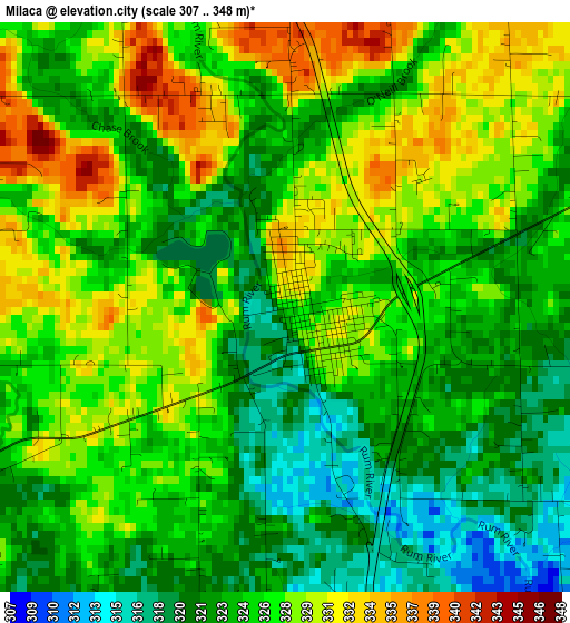
Below is the Elevation map of Milaca, which displays elevation range with different colors. Scale of the first map is from 307 to 348 m (1007 to 1142 ft) with average elevation of 325.4 meters (=1068 ft) [note 1]
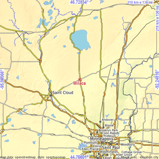
These maps also provides idea of topography and contour of this city, they are displayed at different zoom levels. More info about maps, scale and edge coordinates you can find below images.
| \ | Map #1 | Topo.Map |
| Scale [m] | 307..348 m | × |
| Scale [ft] | 1007..1142 ft | × |
| Average | 325.4 m = 1068 ft | × |
| Width | 6.82 km = 4.2 mi | 218.2 km = 135.6 mi |
| Height | 6.82 km = 4.2 mi | 218.2 km = 135.6 mi |
| ↑Max Latitude | 45.786453° | 46.72834° |
| Latitude at center | 45.7558° | 45.7558° |
| ↓Min Latitude | 45.72513° | 44.76601° |
| ← Min Longitude | -93.698355° | -95.06066° |
| Longitude center | -93.65441° | -93.65441° |
| →Max Longitude | -93.610465° | -92.24816° |
Nearby cities:
Cities around Milaca sort by population:
• Saint Cloud elevation 318 m
45 km,  241°
241°
• Sauk Rapids 314 m
43.7 km,  245°
245°
• Cambridge 291 m
39.1 km,  121°
121°
• Isanti 283 m
43.3 km,  133°
133°
• Zimmerman 301 m
35.1 km,  171°
171°
• Becker 297 m
43.9 km,  203°
203°
• Princeton 299 m
21.4 km,  164°
164°
• Mora 307 m
31 km,  64°
64°
• Foley 345 m
22.3 km, 242°
• Braham 289 m
37.7 km,  95°
95°
• Pierz 356 m
43 km,  305°
305°
• Rice 321 m
43.9 km,  269°
269°
Multilingual:
 En español:
Milaca elevación 327 m.
 En France:
Milaca élévation 327 m.


Sources and notes:
- [note 1] Map square and city borders are not equal. Map elevation data is calculated only from area inside that square.
- [src 1] Elevation data from geonames database provided with same terms of usage.
- [src 2] The elevation map of Milaca is generated using elevation data from NASA's 3 arcsec (90m) resolution SRTM data.
- [src 3] Base (background) map © OpenStreetMap contributors tiles are generated by Geofabrik and OpenTopoMap.
Copyright & License:
This Milaca Elevation Map is licensed under CC BY-SA. You may reuse any part from this page, if you give a proper credit by linking to this URL:
 More info on terms of use page.