Little Falls elevation
Little Falls (Minnesota, Morrison County), United States elevation is 339 meters and Little Falls elevation in feet is 1112 ft above sea level [src 1]. Little Falls is a seat of a second-order administrative division (feature code) with elevation that is 60 meters (197 ft) bigger than average city elevation in United States.
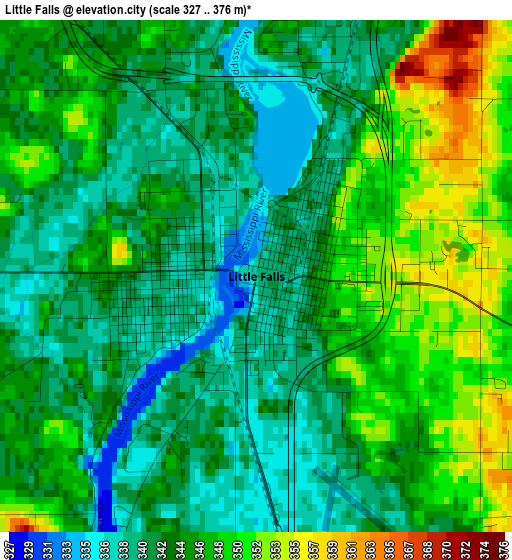
Below is the Elevation map of Little Falls, which displays elevation range with different colors. Scale of the first map is from 327 to 376 m (1073 to 1234 ft) with average elevation of 344.3 meters (=1130 ft) [note 1]
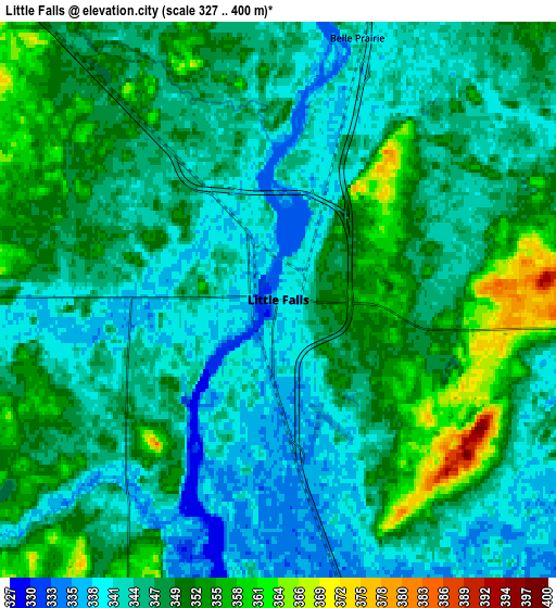
These maps also provides idea of topography and contour of this city, they are displayed at different zoom levels. More info about maps, scale and edge coordinates you can find below images.
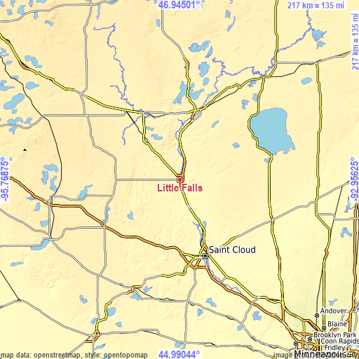
| \ | Map #1 | Map #2 | Topo.Map |
| Scale [m] | 327..376 m | 327..400 m | × |
| Scale [ft] | 1073..1234 ft | 1073..1312 ft | × |
| Average | 344.3 m = 1130 ft | 346.9 m = 1138 ft | × |
| Width | 6.79 km = 4.2 mi | 13.58 km = 8.4 mi | 217.3 km = 135 mi |
| Height | 6.79 km = 4.2 mi | 13.58 km = 8.4 mi | 217.3 km = 135 mi |
| ↑Max Latitude | 46.006882° | 46.037396° | 46.94501° |
| Latitude at center | 45.97635° | 45.97635° | 45.97635° |
| ↓Min Latitude | 45.945802° | 45.915236° | 44.99044° |
| ← Min Longitude | -94.406445° | -94.450391° | -95.76875° |
| Longitude center | -94.3625° | -94.3625° | -94.3625° |
| →Max Longitude | -94.318555° | -94.274609° | -92.95625° |
Nearby cities:
Cities around Little Falls sort by population:
• Sartell elevation 315 m
41.2 km,  162°
162°
• Sauk Rapids 314 m
45.4 km, 160°
• Brainerd 365 m
44.2 km,  16°
16°
• Baxter 366 m
41.2 km,  8°
8°
• Saint Joseph 334 m
45.9 km,  175°
175°
• Collegeville 333 m
42.5 km, 180°
• Long Prairie 392 m
38.9 km,  269°
269°
• Albany 368 m
41.7 km,  202°
202°
• Avon 344 m
41.4 km,  189°
189°
• Pierz 356 m
19.9 km,  88°
88°
• Rice 321 m
27.3 km, 156°
• Royalton 329 m
17.1 km, 161°
Multilingual:
 En español:
Little Falls elevación 339 m.
 En France:
Little Falls élévation 339 m.
 Auf Deutsch:
Little Falls höhe über dem Meeresspiegel ist 339 m.

Sources and notes:
- [note 1] Map square and city borders are not equal. Map elevation data is calculated only from area inside that square.
- [src 1] Elevation data from geonames database provided with same terms of usage.
- [src 2] The elevation map of Little Falls is generated using elevation data from NASA's 3 arcsec (90m) resolution SRTM data.
- [src 3] Base (background) map © OpenStreetMap contributors tiles are generated by Geofabrik and OpenTopoMap.
Copyright & License:
This Little Falls Elevation Map is licensed under CC BY-SA. You may reuse any part from this page, if you give a proper credit by linking to this URL:
 More info on terms of use page.