Glenville elevation
Glenville (West Virginia, Gilmer County), United States elevation is 224 meters and Glenville elevation in feet is 735 ft above sea level [src 1]. Glenville is a seat of a second-order administrative division (feature code) with elevation that is 55 meters (180 ft) smaller than average city elevation in United States.
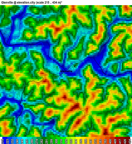
Below is the Elevation map of Glenville, which displays elevation range with different colors. Scale of the first map is from 215 to 434 m (705 to 1424 ft) with average elevation of 296.9 meters (=974 ft) [note 1]
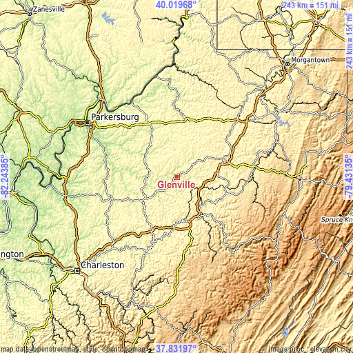
These maps also provides idea of topography and contour of this city, they are displayed at different zoom levels. More info about maps, scale and edge coordinates you can find below images.
| \ | Map #1 | Topo.Map |
| Scale [m] | 215..434 m | × |
| Scale [ft] | 705..1424 ft | × |
| Average | 296.9 m = 974 ft | × |
| Width | 7.6 km = 4.7 mi | 243.3 km = 151.2 mi |
| Height | 7.6 km = 4.7 mi | 243.2 km = 151.1 mi |
| ↑Max Latitude | 38.968435° | 40.01968° |
| Latitude at center | 38.93426° | 38.93426° |
| ↓Min Latitude | 38.900068° | 37.83197° |
| ← Min Longitude | -80.881545° | -82.24385° |
| Longitude center | -80.8376° | -80.8376° |
| →Max Longitude | -80.793655° | -79.43135° |
Nearby cities:
Cities around Glenville sort by population:
• Clarksburg elevation 306 m
57.4 km,  47°
47°
• Buckhannon 437 m
52.8 km,  82°
82°
• Weston 313 m
34 km,  70°
70°
• Spencer 231 m
46.8 km,  251°
251°
• Harrisville 262 m
35.8 km,  328°
328°
• Salem 322 m
45.6 km,  31°
31°
• Pennsboro 261 m
40.6 km,  343°
343°
• Sutton 254 m
32 km,  159°
159°
• Elizabeth 196 m
50.3 km,  286°
286°
• West Union 240 m
40.6 km,  7°
7°
• Grantsville 216 m
22.4 km,  266°
266°
• Clay 216 m
56.9 km,  202°
202°
Multilingual:
 En español:
Glenville elevación 224 m.
 En France:
Glenville élévation 224 m.
 Auf Deutsch:
Glenville höhe über dem Meeresspiegel ist 224 m.

Sources and notes:
- [note 1] Map square and city borders are not equal. Map elevation data is calculated only from area inside that square.
- [src 1] Elevation data from geonames database provided with same terms of usage.
- [src 2] The elevation map of Glenville is generated using elevation data from NASA's 3 arcsec (90m) resolution SRTM data.
- [src 3] Base (background) map © OpenStreetMap contributors tiles are generated by Geofabrik and OpenTopoMap.
Copyright & License:
This Glenville Elevation Map is licensed under CC BY-SA. You may reuse any part from this page, if you give a proper credit by linking to this URL:
 More info on terms of use page.